What is SAR Satellite Imagery? How Radar Sees What Optical Can't
SAR satellites use radar to image Earth through clouds, at night, in any weather. Learn how synthetic aperture radar works and which SAR satellites to use.
Summary
- Synthetic aperture radar (SAR) satellites image Earth using radar pulses, not sunlight. They see through clouds, work at night, and don’t care about weather. Optical satellites can’t do any of that.
- Two free SAR data sources now exist: ESA’s Sentinel-1C (C-band, 5-40m) and NASA/ISRO’s NISAR (L-band + S-band, 5-10m), which started releasing data in early 2026.
- Commercial SAR resolution has hit 16cm from ICEYE and Umbra. That rivals the best optical satellites.
- SAR captures completely different information than optical — surface roughness, moisture, ground deformation — and works best when combined with optical data.
- The wavelength matters more than you’d think. X-band sees the surface. L-band sees through entire forest canopies. P-band goes into the soil.
Last month, Planet Labs told its customers they’d have to wait 14 days for optical satellite imagery over the Middle East. Fourteen days. The US had just launched strikes on Iranian targets, and apparently nobody wanted commercial satellite photos showing the aftermath circulating on Twitter.
SAR imagery from other providers? Available as normal. No restrictions.
That one detail tells you almost everything about the difference between optical and synthetic aperture radar satellite imagery. Optical photos are intuitive — anyone can look at them and understand what they’re seeing, which is exactly what makes them politically sensitive. SAR images look like grainy TV static to untrained eyes, even though they contain a staggering amount of information.
We deal with optical imagery every day at Geopera. We process thousands of orders from providers like Maxar/Vantor, 21AT, and CGSTL. But the question we keep getting is: “What about radar?” So let’s talk about it.
The Embarrassingly Simple Idea Behind SAR
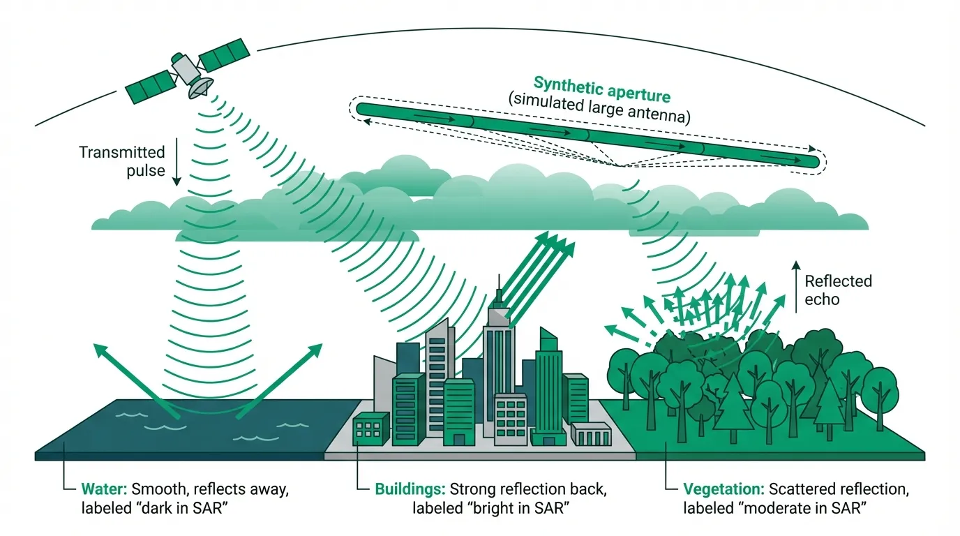
Here’s the concept: shout at a wall and listen to the echo.
That’s it. That’s synthetic aperture radar. A satellite fires microwave pulses at the ground and records what bounces back. Different surfaces bounce radar differently — buildings reflect it straight back (loud echo), water reflects it away like a mirror (silence), trees scatter it in every direction (messy echo).
The “synthetic aperture” part is the trick that makes it actually useful. To get a sharp radar image from space, you’d need an antenna hundreds of metres long. Nobody’s launching that. Instead, SAR exploits the fact that the satellite is moving. As it flies along its orbit, it fires pulses and records echoes from thousands of slightly different positions. Then software stitches all those returns together to simulate the effect of one enormous antenna.
Think of it like dragging a microphone across a room while someone claps — you hear the clap from many positions, and your brain combines them to pinpoint exactly where the sound came from. SAR does this with radar at 7km/s from 500km up.
The result: detailed imagery from an antenna that’s actually only a few metres wide, taken through clouds, at midnight, during a monsoon. Optical satellites are sitting this one out completely.
Not All Radar is Created Equal
Here’s where it gets fun. SAR satellites don’t all use the same type of radar. The wavelength they transmit determines what they can see and — this is the critical part — how deep they can look.
Short wavelengths (X-band, ~3cm) bounce off the very top of whatever they hit. Leaves, rooftops, the surface of water. Great for seeing fine detail, terrible for seeing beneath anything.
Long wavelengths (L-band, ~23cm) pass right through leaves, branches, and light vegetation to interact with trunks and the ground below. Imagine the difference between throwing a tennis ball at a chain-link fence versus a basketball — the basketball goes through gaps the tennis ball can’t.
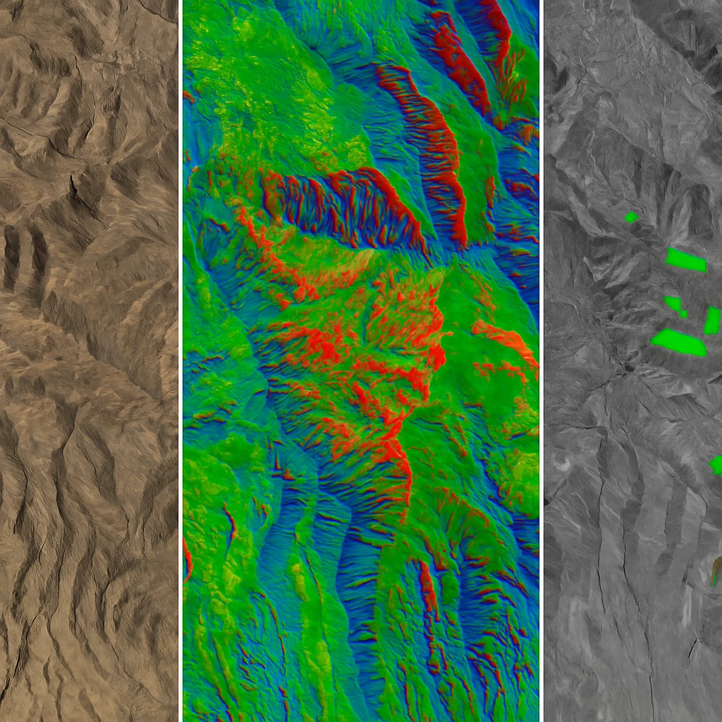
P-band (~69cm) goes even further, penetrating into dry soil and dense vegetation. ESA’s upcoming BIOMASS satellite uses P-band specifically because it can measure forest biomass by interacting with the largest branches and trunks that contain most of the carbon.
Why does this matter practically?
If you’re monitoring deforestation in the Amazon — where cloud cover blocks optical satellites for half the year — you need L-band SAR that cuts through both the clouds AND the canopy. C-band won’t get through dense tropical forest. X-band won’t even get through the leaves.
But if you’re tracking ship movements in open water? X-band gives you the sharpest, crispest images at the highest resolution. Horses for courses.
The SAR Satellites You Can Actually Use in 2026
Five years ago, your SAR options were basically Sentinel-1 or writing a very large cheque to a government agency. That’s changed dramatically.
The Free Stuff
Sentinel-1C (ESA) launched December 2024 after Sentinel-1B died unexpectedly in 2022 (just… stopped working, like a printer on a Monday morning, except this one cost €300 million). C-band, 5-40m resolution, 12-day revisit, and the entire archive is free through the Copernicus Data Space.
NISAR (NASA/ISRO) is the big one. Launched July 2025 with both L-band and S-band instruments. It maps every landmass on Earth every 12 days at 5-10m resolution and generates 85 terabytes of data per day. Over 100,000 data products hit the Alaska Satellite Facility in February 2026, with fully calibrated global data coming mid-2026. All free. All open access. L-band SAR data at this scale has simply never existed before.
The Commercial Stuff
A few things jump out from that chart.
ICEYE (Finland) and Umbra (US) both deliver 16cm resolution from commercial constellations. Each satellite weighs under 100kg. That’s comparable to what Maxar achieves with optical at 15cm — except the radar version works through clouds and at night.
Synspective (Japan) is launching its 8th StriX satellite this month and building toward a 30-satellite constellation. Capella Space offers 31cm, still sub-metre, still impressive. Both are X-band.
The older systems — TerraSAR-X (Airbus, launched 2007) and RADARSAT (Canadian Space Agency, 2019) — are lower resolution but cover enormous swaths. Different tools for different jobs.
In Germany, you might search for “SAR-Satelliten” and land on different results than English-language markets. The European SAR ecosystem runs deep: Airbus with TerraSAR-X, ESA with Sentinel-1 and BIOMASS, and a growing constellation of startups like constellr and SatVu in the thermal-adjacent space.
SAR vs Optical: A Practical Decision Guide
Most guides present this as a contest. SAR vs optical, pick a side. That completely misses the point. They capture fundamentally different information about Earth’s surface. The question isn’t “which is better” — it’s “what do I actually need to see?”
See the pattern? SAR dominates anything weather-related, time-related, or deformation-related. Optical dominates anything colour-related, spectral-related, or interpretability-related.
Neither replaces the other. They’re doing different things entirely.
Reach for SAR when:
- Cloud cover makes optical unreliable (tropical regions, monsoon seasons, northern Europe, the UK on any given Tuesday)
- You need imagery regardless of daylight
- You’re measuring ground subsidence or structural deformation with InSAR (millimetre precision, which is honestly absurd from space)
- You’re finding ships, oil spills, or sea ice
- You need to see beneath forest canopy
Reach for optical when:
- You need colour or spectral analysis (vegetation health, water quality, mineral ID)
- Non-technical people need to understand the imagery (boardroom presentations, insurance reports, planning applications)
- You’re calculating vegetation indices like NDVI or EVI
- You need the absolute finest resolution (Maxar at 15cm still edges out commercial SAR)
- Budget is tight (optical archive imagery is generally cheaper per square kilometre)
Use both when the stakes are high. For mining companies monitoring tailings dams, combining optical spectral analysis with SAR-based InSAR deformation tracking provides something neither technology delivers alone. For agricultural monitoring in cloudy regions, SAR fills the gaps between clear-sky optical acquisitions. For disaster response, you can’t afford to wait for clear skies.
What SAR Can’t Do (The Honest Part)
We’d be doing you a disservice if we didn’t mention the limitations. SAR is powerful, but it’s not magic.
Interpretation is hard. SAR images look nothing like photographs. Bright doesn’t mean “light-coloured” — it means “rough surface that reflected radar back at the satellite.” Water appears jet black. Buildings glow. Trees are speckly grey. It takes training to read SAR imagery, and most people outside the remote sensing world find it confusing at first.
Speckle noise is real. Every SAR image has a granular salt-and-pepper texture that makes fine details harder to see. It’s inherent to how coherent radar works — not a processing error. Filtering reduces it but softens detail.
No spectral information. You can’t calculate NDVI from SAR data. You can’t tell the difference between a red roof and a blue roof. If colour matters, you need optical.
Geometric distortions near mountains. Tall features “lean” toward the satellite in SAR images (called layover). Mountains cast radar shadows. Slopes facing the satellite get compressed (foreshortening). Processing handles some of this, but steep terrain is always harder.
It won’t see through solid rock. Despite what movies suggest, SAR doesn’t see underground in any meaningful way. L-band penetrates a metre or two into dry sand. P-band reaches a few metres into dry soil. But wet ground, rock, concrete, metal? Nothing gets through.
Where This Fits With What We Do
We process optical satellite imagery at Geopera — orthorectification, pansharpening, atmospheric correction, spectral index calculation. That’s our core. Every order gets the full treatment at no extra cost, because we think unprocessed imagery isn’t worth delivering.
The SAR question comes up more and more. And honestly, the answer is usually “you need both.” Optical gives you the spectral richness. SAR gives you the all-weather reliability. Together they get you something closer to continuous situational awareness than either manages alone.
If you’re figuring out what mix of optical and SAR fits your project — or you just need properly processed satellite imagery from any of the major providers — talk to our team. We’ll help you work it out without overselling you something you don’t need.
Or poke around the Pera Portal yourself.
Frequently Asked Questions
What is synthetic aperture radar used for?
SAR is used for flood mapping through clouds, ground deformation monitoring in mining and infrastructure (via InSAR, with millimetre precision), crop monitoring during cloudy seasons, deforestation detection beneath forest canopy, maritime surveillance, and defence. The key advantage is that SAR works in any weather and at any time of day.
How does synthetic aperture radar work?
A SAR satellite transmits microwave pulses at Earth and records the reflected energy. As it moves along its orbit, it collects returns from thousands of positions, then computationally combines them to simulate a much larger antenna — the “synthetic aperture.” This creates high-resolution images from a physically small antenna, through clouds and darkness.
Can synthetic aperture radar see underground?
In very limited cases. L-band SAR (23cm wavelength) penetrates 1-2 metres into dry sand and sees through forest canopy to the ground. P-band (69cm) reaches a few metres into dry soil. But SAR can’t see through wet ground, rock, concrete, or metal. The “underground vision” capability depends entirely on the surface material and how dry it is.
How deep can synthetic aperture radar penetrate?
It depends on the band and the material. X-band (~3cm) stays at the surface. C-band (~5.6cm) pushes through light vegetation. L-band (~23cm) gets through forest canopy and 1-2m into dry sand. P-band (~69cm) can reach several metres into dry soil. Water kills penetration at every frequency — even L-band barely gets past wet ground.
Is SAR satellite imagery free?
Some of it. ESA’s Sentinel-1C provides free C-band SAR globally at 5-40m resolution. NASA/ISRO’s NISAR started releasing free L-band and S-band data at 5-10m in 2026. Umbra offers select free imagery through its open data programme. For sub-metre commercial SAR from ICEYE, Capella, Umbra, or Synspective, you’ll need to purchase — pricing depends on resolution, coverage, and licensing.
Related Articles
What You Should Know About Optical Satellite Imagery
How optical satellite imagery works, from spectral bands to spatial resolution, plus practical applications across industries.

ESA BIOMASS Satellite Explained
How the BIOMASS mission uses P-band SAR to map global forest carbon stocks from space.
Best Satellite Imagery for Every Application
Complete guide to selecting the optimal satellite imagery for your specific application needs.
