How to Buy Satellite Imagery in 2025
Complete guide to purchasing commercial satellite imagery in 2025. Learn procurement processes, pricing factors, quality considerations, and how to choose the right provider for your business needs.

Summary
- Define Requirements First: Clearly specify spatial resolution, coverage area, temporal needs, and processing requirements before contacting suppliers
- Understanding Pricing: Base pricing is just the start - traditional providers often add substantial processing fees that can add 30-80% to costs
- Geopera’s Advantage: Always the cheapest pricing with no markup, plus world-class analysis-ready processing (orthorectified, pansharpened, color-balanced, mosaicked) delivered fastest in the industry - sometimes within an hour
- Pera Portal: Instantly browse available imagery for any area worldwide - see exactly what’s available before purchasing
- Procurement Methods: Direct from operators vs resellers vs modern platforms - each has distinct advantages for different use cases
- Quality Matters: Processing quality separates professional-grade imagery from basic products - superior processing extracts more value from any sensor
- Common Pitfalls: Underestimating processing costs, inadequate quality specifications, poor timing considerations, overlooking platform experience
Every day, hundreds of satellites capture terabytes of Earth observation data, but navigating the procurement process can feel overwhelming for first-time buyers. The satellite imagery market has evolved dramatically, with growing accessibility making commercial satellite data more attainable than ever before. However, common misconceptions about cost, complexity, and quality differences between providers often lead businesses to make suboptimal purchasing decisions.
Whether you’re a project manager evaluating satellite data for the first time, a GIS professional expanding your toolkit, or a business decision maker exploring Earth observation capabilities, this comprehensive guide will walk you through everything you need to know about purchasing satellite imagery. You’ll learn how to define your requirements, navigate procurement channels, understand pricing structures, and avoid common pitfalls that can derail your project.
The key to successful satellite imagery procurement lies in understanding not just what you’re buying, but how different providers deliver value through processing quality, platform experience, and ongoing support.
Understanding Your Imagery Requirements
Before approaching any supplier, clearly defining your project requirements will save time and ensure you get quotes that actually meet your needs. The satellite imagery market offers an extensive range of options, and precision in your specifications directly impacts both cost and project success.
Defining Your Project Scope
Start by articulating your project’s core objectives. Are you monitoring environmental changes over time, conducting infrastructure assessments, supporting precision agriculture initiatives, or performing mineral exploration? Each application has distinct imagery requirements that will guide your procurement decisions.
Consider your analytical workflow and end deliverables. If you’re producing detailed maps for regulatory compliance, you’ll need different specifications than someone creating broad-scale environmental monitoring reports. Understanding how the imagery fits into your larger project workflow helps determine processing requirements and delivery formats.
Resolution Requirements
Spatial resolution determines the smallest features you can identify and directly impacts pricing. High-resolution commercial satellites like WorldView-3 offer 30cm resolution, perfect for detailed infrastructure analysis, while medium-resolution sensors provide 1-10m resolution suitable for large-scale monitoring applications.
Temporal resolution refers to how frequently you need updates. Real-time monitoring projects require regular acquisitions, while historical analysis might only need archived imagery. Consider seasonal factors - vegetation monitoring benefits from growing season coverage, while infrastructure projects might prefer cloud-free conditions.
Spectral resolution defines the number and width of spectral bands captured. Standard RGB imagery suffices for basic visual analysis, while multispectral data enables vegetation health monitoring, and hyperspectral imagery supports detailed mineral identification.
Coverage Area and Delivery Considerations
Area of interest (AOI) size significantly impacts pricing structures. Small, precise areas often cost more per square kilometer than large coverage areas. Consider whether you need seamless mosaics across boundaries or can work with individual scene tiles.
Timeline requirements affect both cost and availability. Rush orders for fresh imagery typically carry premium pricing, while archived imagery offers more predictable costs and immediate availability. Factor processing time into your project schedule - even archived imagery may require several days for custom processing and delivery.
Types of Satellite Imagery Available
The commercial satellite imagery market offers diverse options across resolution, spectral capabilities, and processing levels. Understanding these differences helps you match imagery types to your specific application requirements and budget constraints.
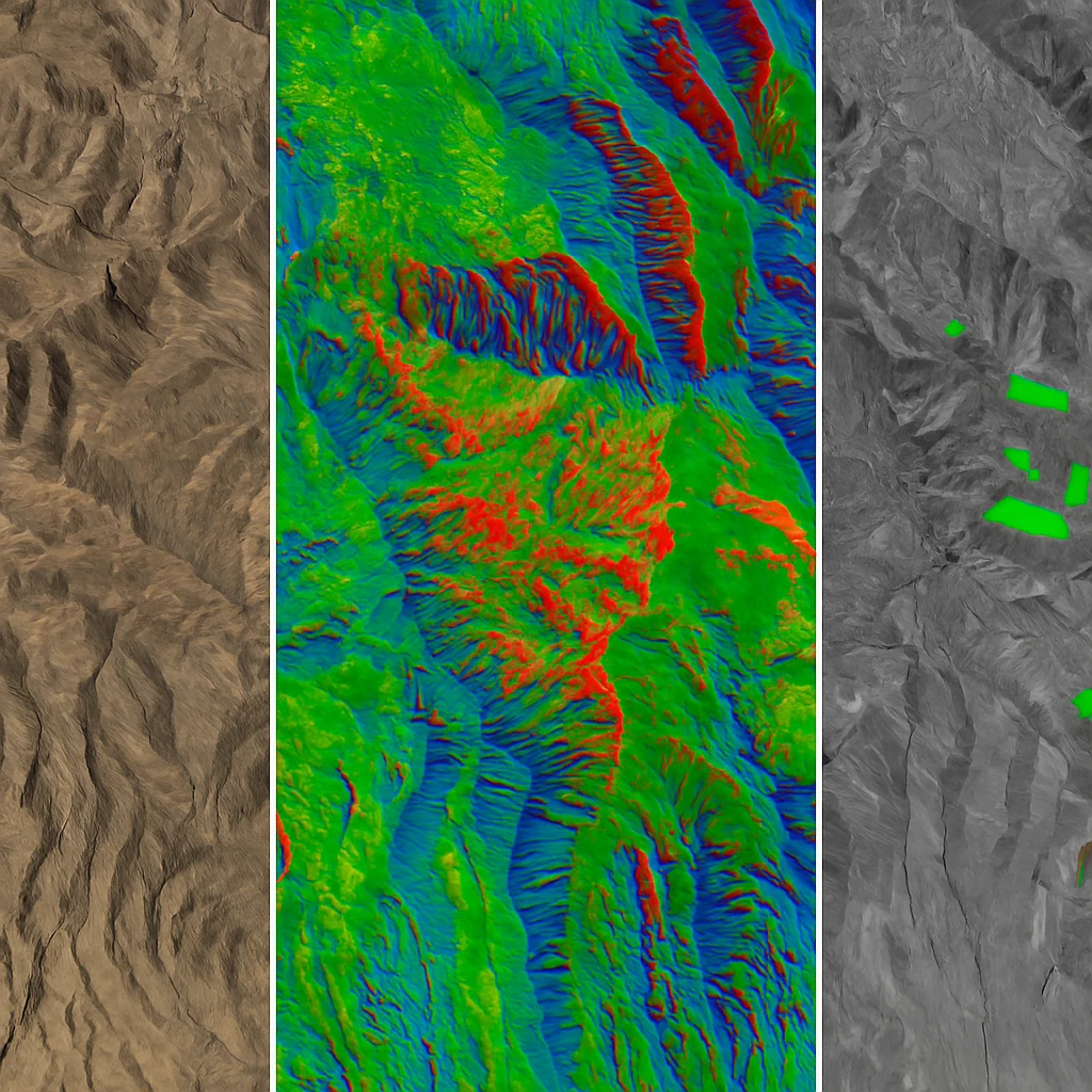
Optical vs Radar Imagery
Optical satellites capture reflected sunlight across visible and infrared spectra, providing intuitive imagery that’s easy to interpret. They excel for vegetation monitoring, infrastructure mapping, and general earth observation but are limited by cloud cover and require daylight conditions.
Radar satellites use synthetic aperture radar (SAR) to penetrate clouds and operate day or night, making them invaluable for all-weather monitoring, flood mapping, and ground deformation studies. While more complex to interpret, radar imagery provides unique capabilities for specific applications.
High-Resolution Commercial Satellites
Leading commercial providers offer sub-meter resolution imagery through advanced satellites:
- WorldView-3 and WorldView-4 deliver 30cm panchromatic and 1.2m multispectral resolution with excellent geometric accuracy
- Jilin-1 provides 50cm resolution with excellent coverage and competitive pricing, featuring a large constellation for frequent revisits
These high-resolution systems excel for detailed infrastructure analysis, precision agriculture, urban planning, and security applications where fine detail matters.
Medium and Low Resolution Options
Landsat and Sentinel missions provide free satellite imagery with 10-30m resolution and excellent temporal coverage, perfect for large-scale monitoring and change detection applications.
Commercial medium-resolution satellites like SkySat offer 50cm resolution with high revisit frequencies, balancing detail and cost for dynamic monitoring applications.
Processing Levels: Why Analysis-Ready Matters
This is where provider choice becomes critical. Raw satellite imagery requires extensive processing before analysis - geometric correction, radiometric calibration, atmospheric compensation, and often pansharpening and mosaicking.
Traditional providers often charge substantial fees for these processing steps, with basic orthorectification alone adding significant costs to your project. These processing fees can add 30-80% to your imagery costs with traditional vendors.
Modern platforms like Geopera include analysis-ready processing at no additional cost compared to unprocessed imagery. Every image is perfectly orthorectified, pansharpened, color-balanced, and mosaicked using the world’s most advanced preprocessing. This approach eliminates surprise fees and ensures you receive imagery that’s immediately ready for analysis.
Procurement Methods and Platform Comparison
The method you choose for procuring satellite imagery significantly impacts your experience, costs, and final image quality. Understanding the advantages and limitations of each approach helps you select the right procurement strategy.
Traditional Vendor Relationships
Direct relationships with satellite operators offer access to full archives and tasking capabilities, but often involve complex negotiations, minimum purchase requirements, and lengthy procurement cycles. These relationships work well for large organizations with consistent, high-volume needs.
Leading imagery resellers and distributors provide access to multiple satellite sources through single relationships, simplifying vendor management. The best resellers like Geopera offer competitive pricing without markup while providing superior processing capabilities and faster delivery than going direct to operators.
Why Pera Portal Sets the Standard
Modern procurement platforms have revolutionized how businesses access satellite imagery. Geopera’s Pera Portal exemplifies this evolution, offering instant access to browse available imagery for any area of interest worldwide.
Unlike traditional complex procurement workflows that require multiple emails, technical discussions, and lengthy quote processes, Pera Portal lets you instantly explore what’s available. You can see exactly what imagery exists for your project area, review acquisition dates and quality metrics, and access data immediately.
The platform experience matters because traditional vendor portals often require you to submit requests blind, hoping suitable imagery exists. With Pera Portal’s transparent approach, you know exactly what’s available before making any commitments.
Key Features That Matter in Procurement Platforms
Instant browsing capabilities eliminate the guesswork common with traditional procurement. Being able to preview imagery quality, coverage, and specifications before purchase prevents costly mistakes.
Processing transparency distinguishes superior platforms. While many providers charge extra for basic processing steps, leading platforms include comprehensive processing as standard, delivering analysis-ready imagery without hidden fees.
Quality guarantees built into the platform ensure consistent results. Geopera’s commitment to delivering perfectly processed imagery - orthorectified, pansharpened, color-balanced, and mosaicked - means every download meets professional standards.
Pricing Factors and Cost Considerations
Understanding satellite imagery pricing helps you budget accurately and compare offerings effectively. Pricing structures vary significantly between providers, and hidden costs can substantially impact your total investment.
Per Square Kilometer Pricing
Most commercial imagery is priced per square kilometer, with rates varying by resolution, sensor, and processing level. High-resolution imagery (30-50cm) typically ranges from $15-50 per square kilometer, while medium resolution (1-5m) costs $5-20 per square kilometer.
However, base pricing only tells part of the story. Many providers add substantial processing fees that can increase costs by 30-80%. These “extras” include geometric correction, radiometric calibration, pansharpening, and atmospheric compensation - all essential for professional applications.
The Hidden Cost of Processing
Many providers charge separately for processing steps that are essential for analysis:
- Orthorectification: $2-8 per square kilometer
- Pansharpening: $1-5 per square kilometer
- Atmospheric correction: $2-6 per square kilometer
- Color balancing and mosaicking: $3-10 per square kilometer
These processing fees can add 30-80% to your imagery costs with traditional vendors.
Geopera’s transparent approach eliminates these surprise costs by including analysis-ready processing at no additional cost compared to unprocessed imagery. When you see pricing through Pera Portal, you’re seeing the complete cost for imagery that’s immediately ready for analysis.
Volume Discounts and Licensing
Large area coverage often qualifies for volume discounts, with pricing breaks typically occurring at 1,000+ square kilometers. Multi-user licensing can provide additional value for organizations with multiple teams requiring access.
Consider your total cost of ownership, including processing requirements, delivery formats, and ongoing support. The best value comes from providers like Geopera that offer the lowest base pricing combined with comprehensive processing included at no additional cost, plus industry-leading delivery speed.
The Procurement Process Step-by-Step
Understanding the procurement workflow helps you plan timelines and manage expectations throughout your imagery acquisition project.
Requirements Definition and Feasibility
Begin by documenting your precise requirements: spatial resolution, spectral bands, temporal coverage, area of interest boundaries, and processing specifications. Clear requirements prevent scope creep and ensure accurate quotes.
Modern platforms streamline this process. With Pera Portal, you can instantly verify imagery availability for your area of interest, eliminating the uncertainty common with traditional procurement. You’ll see exactly what’s available before investing time in detailed requirements gathering.
Sensor Selection and Technical Evaluation
Match sensor capabilities to your application requirements. Consider factors like geometric accuracy, spectral band configuration, and revisit frequency alongside basic resolution specifications.
Processing capability becomes crucial here. Evaluate not just raw sensor specifications, but how different providers deliver the final product. Superior processing can extract more value from moderate-resolution sensors than poor processing from high-resolution sources.
Quote Evaluation and Provider Comparison
Compare total project costs, including all processing and delivery fees. Evaluate processing quality standards, delivery timelines, and ongoing support capabilities.
Look beyond base pricing to understand true value. Leading resellers like Geopera often provide the best overall value by offering the lowest base pricing combined with superior processing quality and fastest delivery times.
Order Processing and Quality Assurance
Professional providers implement quality control checkpoints throughout processing workflows. Geopera’s processing pipeline ensures every image meets strict standards for geometric accuracy, radiometric quality, and visual consistency before delivery.
Processing timelines vary by provider and complexity. Archive imagery with standard processing typically delivers within 2-5 business days with traditional providers, while leading platforms like Geopera can deliver fully processed, analysis-ready imagery in as little as one hour.
Delivery and Integration
Consider delivery formats and integration requirements with your existing workflows. Professional providers offer multiple format options and coordinate delivery methods to minimize integration challenges.
Quality Assurance and Technical Specifications
Image quality directly impacts analysis accuracy and project success. Understanding quality standards helps you evaluate providers and ensure deliverables meet your requirements.
Geometric and Radiometric Accuracy
Geometric accuracy determines how precisely imagery aligns with real-world coordinates. Professional applications typically require sub-pixel accuracy for reliable measurements and overlay analysis.
Radiometric quality affects spectral analysis accuracy and visual consistency. Proper calibration ensures reliable vegetation indices, change detection, and multi-temporal analysis.
Processing Quality Standards
Processing quality separates professional-grade imagery from basic products. Geopera’s world-class preprocessing ensures every image is perfectly orthorectified, pansharpened, color-balanced, and mosaicked to professional standards.
This processing excellence means imagery is immediately ready for analysis without additional correction steps, saving time and ensuring consistent results across your project.
Metadata and Documentation
Comprehensive metadata enables proper analysis and reproducible results. Professional providers include detailed processing reports, geometric accuracy assessments, and calibration information with every delivery.
Common Pitfalls and How to Avoid Them
Learning from common procurement mistakes helps ensure project success and budget compliance.
Underestimating Processing Requirements
Many first-time buyers focus solely on acquisition costs without considering processing requirements. Raw imagery requires extensive processing before analysis, often doubling project costs with traditional providers.
Solution: Choose providers like Geopera that include analysis-ready processing at no additional cost compared to unprocessed imagery, eliminating surprise costs and ensuring immediate usability.
Inadequate Quality Specifications
Failing to specify quality requirements often results in imagery that doesn’t meet project needs. Cloud cover thresholds, geometric accuracy requirements, and processing standards should be clearly defined upfront.
Poor Timing and Seasonal Considerations
Seasonal factors significantly impact imagery suitability. Vegetation studies require growing season coverage, while infrastructure projects benefit from leaf-off conditions for better ground visibility.
Overlooking Platform Experience
Traditional procurement processes can be cumbersome and opaque. Modern platforms offering instant browsing and transparent pricing significantly improve procurement efficiency and reduce risks.
Getting Started: Your Next Steps
Ready to explore satellite imagery for your project? The modern procurement landscape offers unprecedented access to high-quality imagery through user-friendly platforms.
Start by exploring what’s available. Browse Geopera’s Pera Portal to instantly see imagery options for your area of interest. You’ll get immediate visibility into coverage, quality, and availability without any commitments.
Consult with imagery experts to ensure your approach aligns with project objectives. Geopera’s team combines technical expertise with practical experience to help you optimize imagery selection and processing requirements.
Consider starting with pilot projects to evaluate providers and refine requirements before larger investments. This approach helps validate your imagery strategy and build internal capabilities.
Experience the difference with Pera Portal - browse available imagery instantly and discover how analysis-ready processing at no additional cost compared to unprocessed imagery saves time and money. Our expert team is ready to help you navigate the procurement process and ensure you get perfectly processed imagery that meets your specific needs.
Explore available imagery through our Pera Portal or contact our expert team for a personalized consultation on your satellite imagery requirements.
Related Articles

What is Satellite Imagery?
A comprehensive guide to satellite imagery technology, its various types, and commercial applications across industries.
Google Earth vs Commercial Satellite Imagery
Detailed comparison between free Google Earth imagery and premium commercial satellite data for professional applications.
Best Free Sources of Satellite Data
Comprehensive guide to accessing free satellite imagery from government agencies and open data initiatives.