Understanding Stereoscopic Satellite Imagery: From Capture to DEM
Learn how stereoscopic satellite imagery creates accurate 3D elevation models from two 2D images captured from different angles.
Summary
- What It Is: Stereoscopic imagery captures the same location from two different angles, creating a stereo pair that contains 3D information
- How It Works: Satellites capture two images 45-90 seconds apart during the same orbital pass, creating geometric disparity that reveals elevation
- The Process: Photogrammetric algorithms match pixels between images, calculate disparity, and generate precise elevation models (DEMs)
- The Products: Strip DEMs provide timestamped elevation data for change detection; mosaic DEMs cover large areas for regional analysis
- Best Sensors: WorldView-1, WorldView-2, and WorldView-3 produce the highest quality DEMs, with WorldView Legion adding new capabilities
- Access at Geopera: Browse existing stereo imagery in our Pera Portal or contact us for custom new collections
A single satellite image shows you terrain in two dimensions. But when that same location is captured from two different angles, something remarkable happens—the images contain enough information to calculate precise elevation data across the entire scene.
This is stereoscopic satellite imagery, and it’s the foundation for creating accurate Digital Elevation Models (DEMs) that reveal the three-dimensional structure of Earth’s surface.
Understanding Monoscopic vs Stereoscopic Collection
Traditional satellite imagery is monoscopic—a single image captured from one viewing angle. While valuable for many applications, monoscopic imagery provides no direct information about elevation or terrain relief.
Stereoscopic collection changes this by acquiring two images of the same location from different angles. These paired images—called a stereo pair—create the geometric conditions necessary to extract elevation data through photogrammetric processing.
The key difference: stereoscopic imagery doesn’t just show what’s on the ground. It shows how high or low that ground is.
How Satellites Capture Stereo Pairs
Modern high-resolution satellites like Vantor’s WorldView constellation (formerly Maxar) have sophisticated pointing capabilities that enable stereoscopic collection through two primary methods.
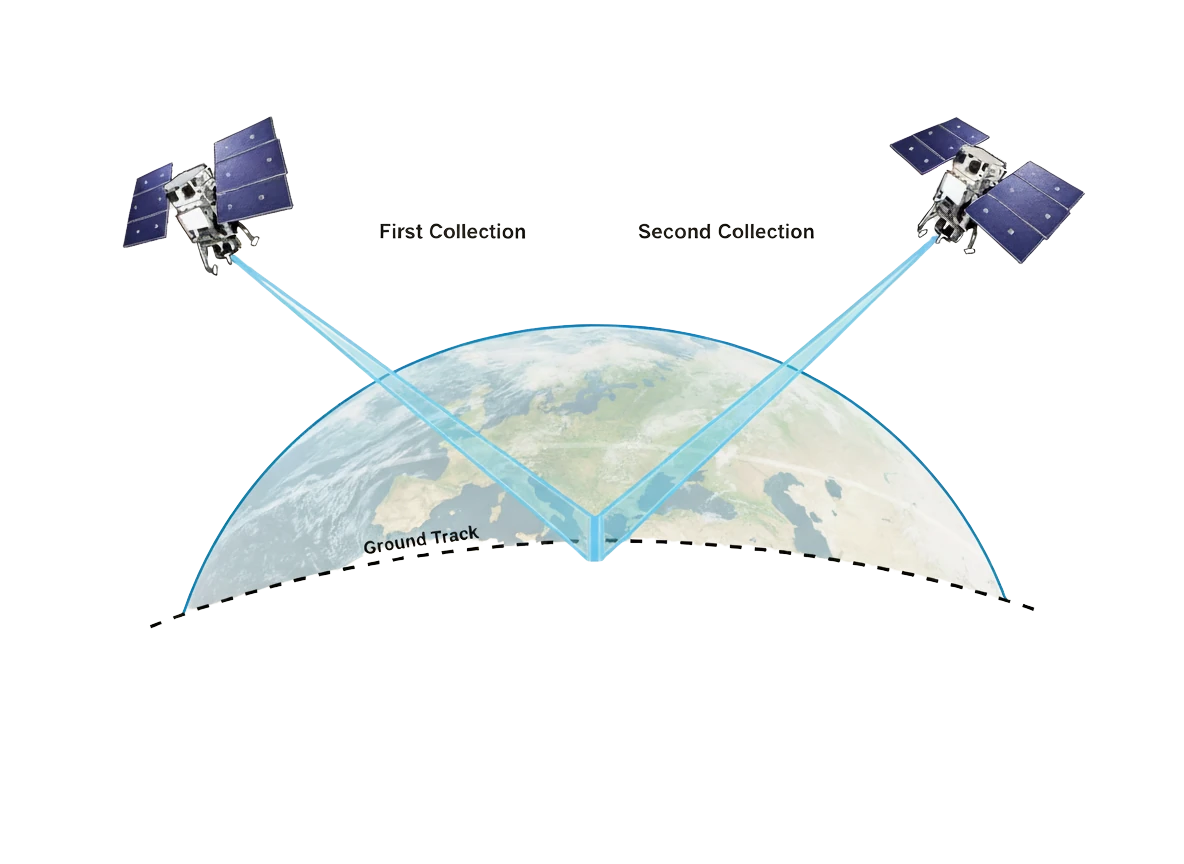
In-Track Stereo Collection
The most common approach is in-track stereo, where both images are captured during a single orbital pass.
Here’s how it works:
- The satellite captures the first image while passing over the target location
- It continues along its orbit for 45-90 seconds
- The satellite rotates its camera to point back at the same location
- It captures the second image from a different viewing angle
Because both captures occur within about 90 seconds, very little changes on the ground between shots. This temporal consistency is crucial—vehicles, shadows, and other transient features remain nearly identical, which improves the reliability of the photogrammetric matching process.
Cross-Track Stereo Collection
An alternative method is cross-track stereo, where the satellite completes at least one full orbit between captures. This creates a stereo pair from different orbital paths, resulting in a larger baseline (the distance between viewing positions) and potentially greater geometric separation.
However, the time gap between captures—typically 90 minutes or more—means ground conditions may have changed. Moving vehicles, shifting shadows, and even changing atmospheric conditions can complicate the matching process and reduce accuracy.
For most applications, in-track stereo delivers superior results.
The WorldView Constellation
All satellites in Vantor’s WorldView constellation support stereoscopic collection, including:
- WorldView-1 (panchromatic only)
- WorldView-2 (8-band multispectral)
- WorldView-3 (16-band SWIR + multispectral)
- WorldView-4 (decommissioned 2019)
- Six WorldView Legion satellites (launched 2023-2024)
While all these sensors can collect stereo imagery, WorldView-1, WorldView-2, and WorldView-3 produce the most accurate DEMs due to their refined sensor models and extensive calibration data. The WorldView Legion constellation also delivers excellent stereo capabilities with improved revisit times and global coverage.
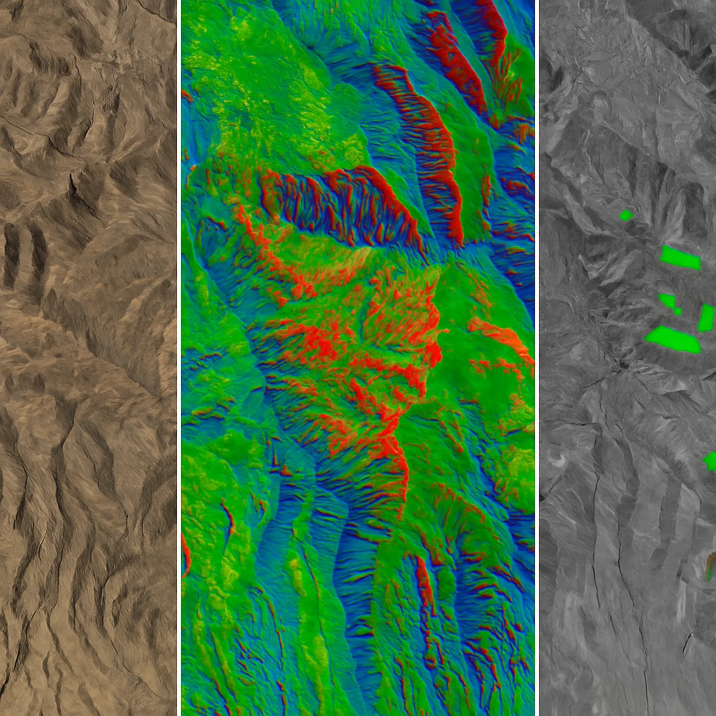
From Two 2D Images to 3D Elevation Data
The transformation from stereo pair to elevation model relies on photogrammetry—the science of making measurements from photographs. The process involves several computational steps that convert geometric disparity between images into precise elevation values.
Step 1: Image Matching
Photogrammetric algorithms first identify corresponding features between the two images. Unlike traditional feature matching that focuses on distinctive points, DEM extraction attempts to match every single pixel with its corresponding pixel in the second image.
This pixel-by-pixel correspondence is where the geometric magic happens. Because the two images were captured from different angles, any given ground feature will appear in slightly different positions in each image. This positional difference—the disparity—is directly related to that feature’s elevation.
Step 2: Calculating Disparity
Once corresponding pixels are identified, the algorithm calculates the precise positional difference between them. A tall building, for instance, will show greater disparity than flat ground because its height causes it to appear in noticeably different locations between the two views.
The relationship between disparity and elevation depends on the collection geometry—specifically, the convergence angle (how different the two viewing angles are) and the satellite’s altitude at the time of capture.
Step 3: Converting Disparity to Coordinates
The satellite’s position during each capture is precisely known, recorded by onboard GPS to centimetre-level accuracy. Using this positional data, the collection geometry, and the measured disparity for each pixel, the algorithms calculate the exact distance from that pixel to the satellite.
With the satellite position known and the distance calculated, basic triangulation provides the pixel’s precise horizontal (x, y) and vertical (z) coordinates in geographic space.
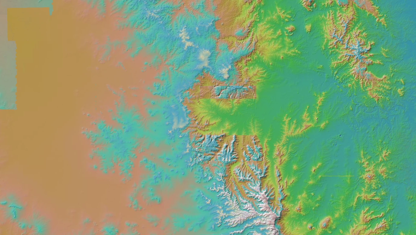
Step 4: Generating the DEM
This process repeats across the entire image extent, producing a dense point cloud—millions of precisely positioned elevation measurements. The algorithm then interpolates a continuous surface through this point cloud, divides it into a regular grid, and writes the result as a raster DEM.
The output is a stereo-derived elevation model where each pixel value represents the elevation at that location.
Strip DEMs vs Mosaic DEMs
Stereo-derived elevation models come in two primary forms, each suited to different applications.
Strip DEMs: Timestamped Elevation Data
A DEM strip is generated from a single stereo pair (or a sequence of stereo pairs collected back-to-back). These strips typically measure 15-17 km wide and 15-100 km long—matching the coverage area of the source imagery.
The defining characteristic of strip DEMs is their timestamp. Because the source images were captured within a narrow time window, the DEM represents the terrain’s elevation at that specific moment in time.
This makes strip DEMs ideal for change detection applications:
- Mining operations: Calculate volumetric changes in stockpiles, pits, and waste dumps over time
- Landslide monitoring: Detect terrain deformation and mass movement
- Coastal erosion: Measure beach and dune elevation changes
- Infrastructure construction: Track earthwork progress on large projects
By collecting multiple stereo pairs over the same area at different times, you can create a time series of elevation models that reveal how the terrain has changed.
Mosaic DEMs: Regional Elevation Coverage
Mosaic DEMs are created by seamlessly blending multiple strip DEMs to cover larger geographic areas—regions, states, or even entire continents.
To avoid visible discontinuities at strip boundaries, the source DEMs are co-registered (aligned precisely to one another) and their edges are blended. The result looks like a single, continuous elevation model.
However, this comes with a trade-off: mosaic DEMs no longer represent a single moment in time. The source strips may have been collected over months or even years, meaning different parts of the mosaic reflect terrain conditions from different dates.
Mosaic DEMs excel at applications requiring broad spatial coverage:
- Regional planning: Infrastructure routing, watershed analysis, flood modeling
- Agricultural drainage design: Topographic mapping for irrigation planning
- Baseline terrain mapping: Creating reference elevation datasets for remote areas
- Geologic mapping: Understanding large-scale landforms and structures
| Feature | Strip DEMs | Mosaic DEMs |
|---|---|---|
| Coverage | 15-100 km strips | Regional to continental |
| Timestamp | Single capture time | Multi-year composite |
| Best For | Change detection, monitoring | Large-area mapping, planning |
| Typical Resolution | 50cm - 1m per pixel | 50cm - 1m per pixel |
| Vertical Accuracy | Sub-meter (with WorldView) | Sub-meter (with WorldView) |
Applications Across Industries
Stereoscopic imagery and the DEMs derived from it serve critical functions across multiple sectors.
Mining
- Volumetric calculations for ore stockpiles and excavations
- Mine pit progression tracking for planning and reporting
- Haul road design and slope stability analysis
- Environmental rehabilitation monitoring
Learn more about satellite imagery for mining operations.
Infrastructure
- Terrain analysis for road, rail, and pipeline routing
- Cut-and-fill calculations for construction planning
- Flood risk modeling along infrastructure corridors
- As-built verification for earthworks projects
Explore applications for infrastructure planning.
Agriculture
- Precision agriculture with topography-informed management zones
- Drainage planning and erosion monitoring
- Terrain-based irrigation system design
- Field-scale elevation mapping for precision planting
See how satellite imagery supports agriculture.
Environmental Monitoring
- Landslide risk assessment and post-event deformation mapping
- Coastal change detection and erosion measurement
- Forest canopy height modeling for biomass estimation
- Watershed and stream network delineation
Discover environmental monitoring capabilities.
Disaster Response
- Before-and-after elevation change detection following earthquakes
- Landslide and debris flow mapping
- Flood extent and impact modeling
- Infrastructure damage assessment
Accessing Stereoscopic Imagery with Geopera
Geopera provides access to stereoscopic satellite imagery from the WorldView constellation, including both existing archive data and new custom collections.
Browse the Archive
Our Pera Portal includes extensive coverage of stereo imagery captured by WorldView satellites worldwide. You can:
- Search for existing stereo pairs over your area of interest
- Preview coverage footprints and acquisition dates
- Filter by sensor, collection date, and quality parameters
- Download imagery directly or stream it for visualization
Many projects can be completed using existing archive imagery, often available for immediate delivery at lower cost than new tasking orders.
Order Custom Stereo Collections
When archive coverage isn’t available or you need current data, Geopera can facilitate tasking orders for new stereoscopic captures. Our team handles:
- Collection planning and feasibility analysis
- Sensor selection based on your DEM accuracy requirements
- Coordination with satellite operators
- Processing and delivery of orthorectified stereo pairs
DEM Extraction Services
If you need the final DEM product rather than raw stereo imagery, Geopera can connect you with photogrammetric processing partners or provide guidance on recommended tools and workflows for DEM extraction.
Not sure which approach is right for your project? Contact our team to discuss your specific requirements. We can help you determine whether archive imagery, new tasking, or alternative elevation data sources best fit your needs and budget.
The Bottom Line
Stereoscopic satellite imagery transforms the way we understand terrain. By capturing the same location from two angles, satellites create the geometric foundation for precise elevation modeling—turning 2D images into 3D intelligence.
For applications that demand accurate elevation data—from mining volumetrics to infrastructure planning to environmental monitoring—stereo-derived DEMs provide a flexible, cost-effective alternative to LiDAR and traditional surveying methods.
Whether you’re tracking elevation changes over time with strip DEMs or mapping large regions with mosaics, stereoscopic imagery delivers the vertical dimension your project requires.
Ready to explore stereo imagery for your project? Browse our archive or contact us to discuss custom collection options.
Related Articles
The 5 Best Free Sources of Elevation Data in Australia
A comprehensive guide to finding and using free Digital Elevation Model (DEM) data sources in Australia.

Orthorectification: Turning Raw Satellite Data Into Map-Ready Imagery
Learn how orthorectification transforms raw satellite imagery into accurate, map-ready products by removing distortions.
Best Satellite Imagery for Every Application
Complete guide to selecting the optimal satellite imagery for your specific application needs and requirements.
