The 5 Best Free Sources of Elevation Data in Australia
A comprehensive guide to finding and using free Digital Elevation Model (DEM) data sources in Australia for environmental studies, engineering projects, and research.
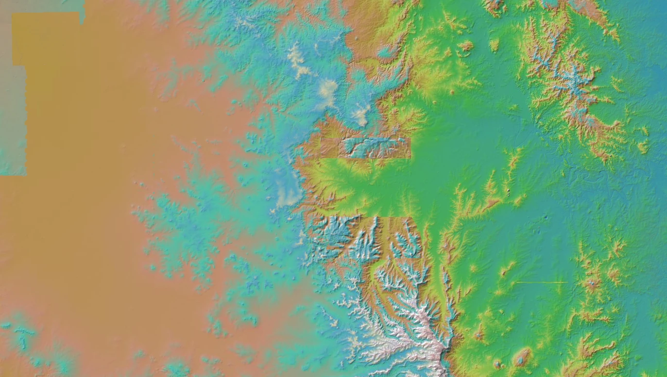
Looking for free elevation data for a site in Australia? This guide compares the free Digital Elevation Model (DEM) sources worth knowing, national, state and global, and what each one is good for. If you already know you want LiDAR from the national portal, our ELVIS elevation data guide walks through ordering, licences and datums in detail.
Summary
ELVIS (Elevation and Depth, Foundation Spatial Data): The national portal for free LiDAR point clouds, LiDAR-derived DEMs and bathymetry from Commonwealth, state and territory custodians
Digital Earth Australia: Best for time-series analysis and environmental monitoring
State-Specific Resources:
- QSpatial (Queensland)
- NSW Spatial Services
- VicMap (Victoria) Best for high-resolution local and regional elevation data
SRTM Data: Best for consistent 30m resolution coverage across Australia
Copernicus DEM: Best for recent, high-accuracy elevation data with global coverage
Understanding Digital Elevation Data
A Digital Elevation Model represents the Earth’s terrain as a three-dimensional digital grid known as a raster GIS layer. Each cell in the grid stores precise elevation information. These heights are measured against what’s known as a vertical datum: a standardised reference surface for zero elevation. In Australia that is usually the Australian Height Datum (AHD), tied to mean sea level, which differs from the ellipsoidal heights satellite imagery uses by up to tens of metres; the datum section of our ELVIS guide shows how much, town by town. These models are fundamental tools for understanding terrain and topography.
Many techniques are used to create digital elevation models, each with its own strengths and applications. Drone photogrammetry excels at capturing detailed data for small project areas. Aerial LiDAR provides precise elevation measurements and can penetrate vegetation, making it ideal for both Digital Surface Models (DSMs) that include buildings and vegetation, and Digital Terrain Models (DTMs) that represent bare earth. Satellite-derived elevation data offers consistent coverage over vast areas, perfect for regional or continental-scale analysis.
Types of Digital Elevation Models
Digital Surface Models (DSM)
DSMs capture the Earth’s surface including all objects on it - buildings, vegetation, and other human-made structures. They’re particularly valuable for urban planning, aviation studies, and vegetation management. These models represent the first surface that would be hit by a raindrop, whether that’s a tree canopy, building roof, or the ground.
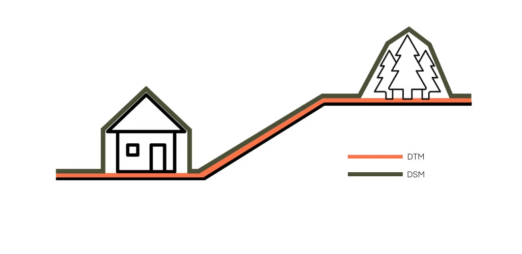 Figure 1: Comparison between DTM and DSM. DTM represents the bare earth surface without buildings and vegetation, while DSM includes all objects on the terrain.
Digital Terrain Models (DTM)
DTMs represent the bare earth surface with all vegetation and built structures removed. This makes them ideal for flood modelling, watershed analysis, and infrastructure planning. They show the ground level that would be exposed if all buildings and vegetation were removed.
Digital Elevation Models (DEM)
DEM is often used as an umbrella term encompassing both DSMs and DTMs. At larger scales where the distinction between surface features and bare earth becomes less significant (such as with 30m resolution data), the term DEM is commonly used. The choice between these models depends on your project’s requirements - from high-precision local surveys to broad regional studies.
Common Applications
Terrain Analysis and Resource Assessment
DEMs help analysts identify geological features like faults, folds, and lineaments in the terrain. By analysing surface expressions and drainage patterns, field teams can better understand an area’s structural geology and plan their investigation programs more efficiently.
Site Planning and Development
When developing new projects in complex terrain, DEMs are used to optimise site layouts, calculating earthwork volumes, and planning access roads. The elevation data helps engineers determine the most efficient construction approaches while ensuring proper drainage and minimal environmental impact.
Slope Stability Monitoring
Large infrastructure projects use repeated DEM surveys to track subtle changes in ground movement and detect potential stability issues before they occur. This ongoing monitoring is essential for maintaining site safety and preventing costly disruptions that could result from ground movement or landslides.
What’s Available in Australia
If you’re searching for free digital elevation maps in Australia, it’s important to understand what’s available.
Australia benefits from excellent access to open-source elevation data, with multiple options available to suit different project needs. Nation-wide coverage is readily available through 30-meter resolution DEMs, providing a solid foundation for regional analysis.
Higher resolution models, typically 1 to 5 metres and mostly LiDAR-derived, are concentrated around urban centres, coasts and floodplains, where detailed terrain matters most. Several state governments have taken the initiative to release comprehensive statewide elevation models, further expanding access to quality terrain data for specific regions.
Detailed Source Overview
1. ELVIS (Elevation and Depth, Foundation Spatial Data)
ELVIS is Australia’s national elevation portal, hosted by Geoscience Australia and built by agencies under the Intergovernmental Committee on Surveying and Mapping. It is the place to start for any Australian site: draw an area and it lists the released LiDAR surveys, DEMs and bathymetry datasets over it, from under 1 m grids down to the national 1 second SRTM DEM.
Orders are free, need only an email address, and arrive as a zipped download link. Most data is Creative Commons Attribution, with exceptions: Queensland LiDAR under three years old is sold, and Victorian data in ELVIS is CC BY-NC. Our step-by-step ELVIS guide covers order limits, formats, ICSM quality levels and the state-by-state rules.
2. Digital Earth Australia
Digital Earth Australia is a government platform that transforms raw satellite and elevation data into ready-to-use information. It provides powerful tools for understanding Australia’s changing landscape.
Key Features:
- Time-series elevation data
- Advanced analysis tools
- Integration with satellite imagery
- Focus on environmental monitoring
- Regular data updates
3. State-Specific Resources
QSpatial (Queensland)
Queensland’s open data portal offers comprehensive elevation datasets through QSpatial, providing high-quality DEMs particularly for coastal and urban regions.
Key Features:
- 5m resolution LiDAR-derived DEMs
- Excellent coastal coverage
- Regular updates for development areas
- Integration with other spatial datasets
NSW Spatial Services
The NSW Spatial Services portal delivers authoritative elevation data for New South Wales, with particular emphasis on urban and development areas.
Key Features:
- High-resolution elevation data
- Comprehensive urban coverage
- LAZ point clouds and 1 m Cloud Optimised GeoTIFF DEMs under the 2024 product specification
- Detailed metadata
VicMap (Victoria)
VicMap provides Victoria’s foundational elevation dataset, offering consistent coverage across the entire state through their spatial data infrastructure.
Key Features:
- State-wide 10m resolution DEM
- Derived from various data sources including LiDAR
- Regular updates and quality improvements
- Complete coverage across Victoria
Victorian elevation data downloaded through ELVIS is licensed CC BY-NC 4.0, so commercial projects need a licence through an authorised Data Service Provider.
4. Global Digital Elevation Models
SRTM (Shuttle Radar Topography Mission)
The SRTM dataset, collected by NASA in 2000, remains one of the most widely used global elevation datasets due to its consistent quality and complete coverage.
Key Features:
- 30m resolution globally
- Well-validated accuracy
- Complete coverage of Australia
- Suitable for regional analysis
AW3D30
ALOS World 3D 30m (AW3D30) is JAXA’s global elevation dataset, collected between 2006-2011, offering improved accuracy over SRTM particularly in areas of steep terrain.
Key Features:
- 30m resolution global DEM
- Updated more recently than SRTM
- Better handling of void areas
- Improved vertical accuracy
Copernicus DEM
The Copernicus DEM is a recent addition to global elevation datasets, providing high-quality terrain data through the European Union’s Earth observation program.
Key Features:
- Global coverage at 30m resolution (GLO-30)
- Higher resolution (10m) available over Europe only
- Based on TerraSAR-X and TanDEM-X data (2011-2015)
- High absolute vertical accuracy (2-4m)
- Freely available through the Copernicus Data Space Ecosystem
Which Source to Start With
Start with ELVIS for any Australian site, because it already aggregates the state LiDAR programmes and the national grids in one search. If it only offers the 1 second SRTM DEM, compare that against Copernicus GLO-30 and AW3D30 over your area; they are all about 30 m, but they were measured years apart by different instruments. And if the site needs better than 30 m where no LiDAR has been flown, or the ground has changed since the last survey, a stereo satellite DEM is the usual next step.
Need satellite imagery to complement your elevation data? Check out our guide to the 10 free sources of satellite data worth knowing in 2026.
