Satellite Imagery Providers: How to Choose One in 2026
How to compare satellite imagery providers in 2026: operators, resellers and platforms, and the seven questions that decide what you receive.
Summary
- Satellite imagery providers come in four kinds: the operators that fly the satellites, authorised resellers that hold agreements with several operators, marketplaces and API platforms that put many catalogues behind one search, and analytics platforms that sell answers built from imagery.
- At sub-metre resolution the pixels are often identical across channels. A WorldView-3 capture is the same capture whoever sells it, and the operator’s licence travels with it. The providers differ in what they do to it before it reaches you.
- Seven questions separate them: what processing level arrives, how accurately each pixel is placed (CE90, with and without ground control), who may use the data, the smallest order, whether different sensors match, what happens when a capture fails, and how the files reach your systems.
- Going direct suits a steady, high-volume programme on one constellation. A reseller suits buyers who need several sensors under one contract and one invoice, with someone local to call.
- Ask every provider for the same evidence: a processed sample over your own area, the processing report, the licence text and a CE90 figure. Then put the replies side by side.
If you’ve been asked to find a satellite imagery provider, you’ve probably opened a dozen websites that all promise high resolution and fast delivery, with no obvious way to tell them apart. What you need to know is smaller and harder to read off a homepage: which of them will hand your team imagery it can use on the day it lands, under a licence that covers everyone who needs it? We should say up front that Geopera is one of the providers on that list, an authorised reseller with its own ordering platform, so we have a stake in how you answer. These are the questions we’d want a buyer to put to us, and to everyone else on the shortlist.
Four Kinds of Satellite Imagery Provider
Every scene starts with an operator, the company that builds and flies the satellite. WorldView comes from Vantor, Beijing-3 from 21AT, and the Dragonette hyperspectral satellites from Wyvern. Operators sell direct, usually to large programmes, and they license their archives to other companies to resell. Those other companies split three ways.
| Provider type | Who owns the satellites | Catalogue | What usually arrives | Who sets the licence |
|---|---|---|---|---|
| Operator | They do | One constellation | Their standard products, raw to orthorectified | They do |
| Authorised reseller | The operators | Several operators under one agreement | The operator’s product, or a processed delivery | The operator, passed through |
| Marketplace or API platform | The operators | Many catalogues behind one search | Often the operator’s product as supplied | The operator, passed through |
| Analytics platform | Usually not them | Whatever feeds their models | Indices, alerts and maps | Their own terms on the outputs |
The boxes blur in practice. Plenty of companies sit in two of them: Geopera is a reseller that runs a self-service platform, and some analytics companies resell imagery on the side. The label on the website tells you less than two plainer facts, which are what happens to the pixels between the operator’s ground station and your drive, and who answers for it when something is wrong.
The Pixels Are Often the Same
At 30 to 50 cm, commercial imagery comes from a short list of constellations, and most of them sell through more than one channel. Buy a WorldView-3 scene from three providers and you get three copies of one capture, taken on the same day by the same telescope under the same operator licence. The price can change between them, and so can what was done to the file before it reached you.
That second difference can be large. This is one order, as the satellite collected it and as it shipped:
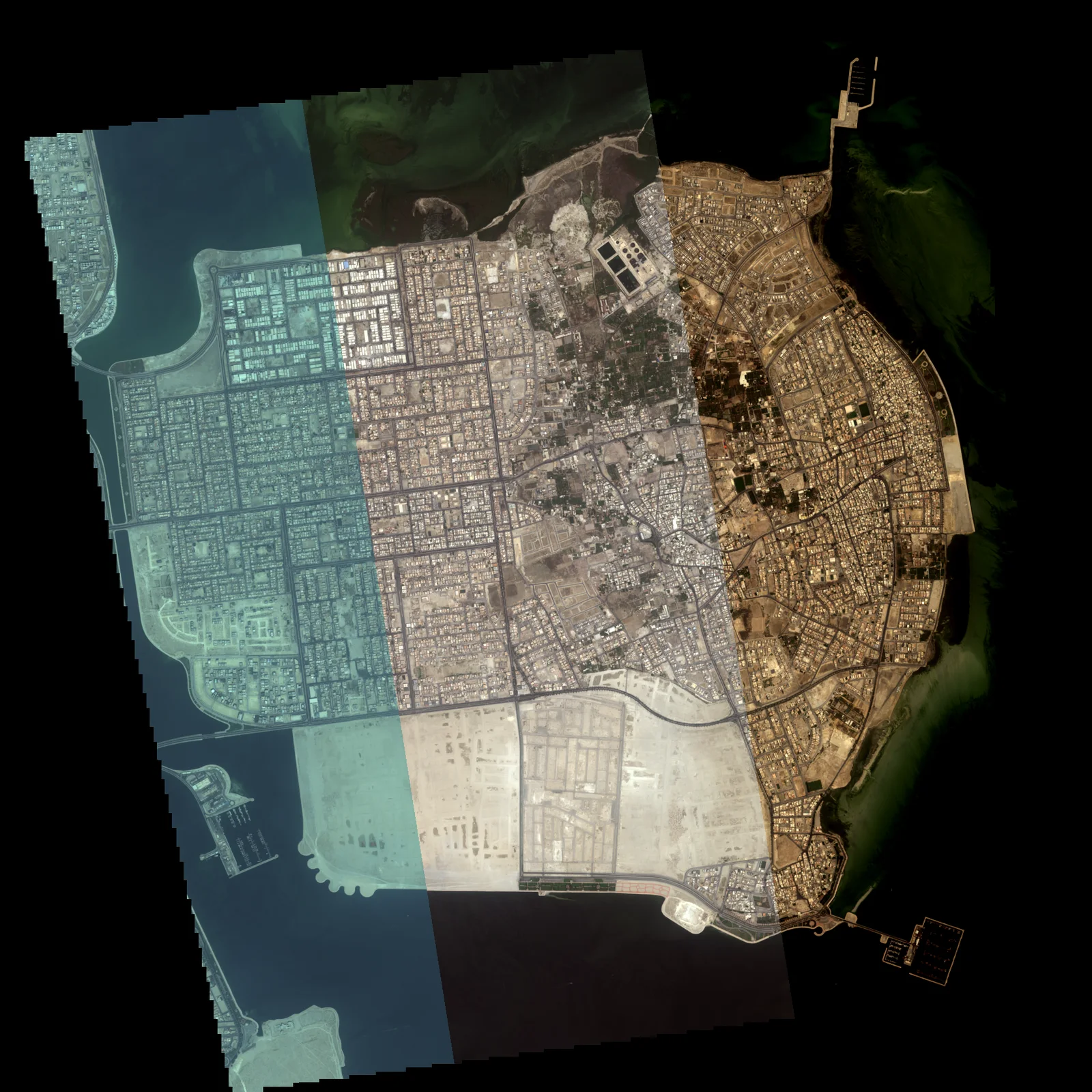
The left side is three captures taken seconds apart. Each one is hazy, sits slightly off the others, and comes out in its own colours. The right side is what the customer received: one image on its true map position, sharpened to 0.3 m and colour-balanced across all three. Both sides are the same photons, so a provider that ships the left has sold you the same satellite as one that ships the right. It has also left you most of the work.
Seven Questions That Separate Providers
Each of these is cheaper to ask before the first delivery than after it.
1. What Processing Level Arrives?
Operators sell their imagery at several processing levels, from basic products in raw sensor geometry, which need orthorectifying before they line up with a map, through to orthorectified, pansharpened and atmospherically corrected files you can open straight into a GIS. A cheap quote is often a basic product. That’s fine if you have a team that does orthorectification and pansharpening every week, and an expensive surprise if you don’t.
Ask for the exact product level in writing, and ask for the processing report that should come with it: which sensor, which capture dates, which steps, against which elevation model. If a provider can’t tell you what was done to the pixels, assume nothing was.
2. Where Does Each Pixel Sit?
Pixel size and positional accuracy are different numbers, and spec sheets lead with the first. Positional accuracy is usually quoted as CE90, the radius that contains 90% of the position errors. WorldView-3, a 31 cm sensor, has a predicted accuracy of less than 3.5 m CE90 without ground control. At a 30 cm pixel that’s about 12 pixels, enough to move a fence line onto the road verge when you overlay your own survey data.
Accuracy is made in processing, by the elevation model and any ground control used to place the image. So ask for CE90 twice, with and without ground control, and ask which elevation model was used. Our ground sample distance guide draws those error circles to scale on real pixels.
3. Who Is Allowed to Use It?
The licence comes from the operator, whichever channel you buy through, and a reseller can’t grant you more than the operator allows. Licences are usually tiered by how many people or organisations will touch the data. A single team is the base case. Several agencies sharing one dataset, a consultant handing results to a client, or imagery printed in a public report can each need a different tier, and that’s the line item most often missing from the first quote.
Name every organisation that will use the imagery before you order, and ask for the licence text itself, not a summary. Export control is the other half of this. It depends on the operator’s home country and the sensor: US operators, for example, are licensed by NOAA’s Commercial Remote Sensing Regulatory Affairs office. Ask for the position sensor by sensor, before the purchase order goes in.
4. What Is the Smallest Order?
Every sensor has a minimum billed area, and usually a minimum width. On our own price list, minimum areas run from 1 km² on some archive products to 100 km² for tasking on others, and minimum widths from 2 to 5 km. A small site gets billed at the minimum, and a long, thin corridor gets widened to the minimum width before it’s priced.
Neither rule is unusual, but not every provider publishes them. Ask for the minimum area and width for every sensor on your shortlist, and whether the minimum applies per order, per scene or per date. Our satellite imagery cost guide works through what a minimum does to the real price of a small site.
5. Will Different Sensors Match?
A one-off image of one site rarely needs this. A programme does. Monitor 40 mine sites quarterly, or build a national mosaic, and you’ll buy from several satellites across several seasons, and each of them sees the world slightly differently. Colours shift between sensors and between dates. Band layouts differ. Two images of the same paddock, taken a month apart by different satellites, can sit metres apart until someone registers them to each other.
Ask whether the provider co-registers dates and sensors to each other, balances colour across them, and gives you a record of how well the alignment worked. The difference shows up the first time you run change detection: unmatched inputs report change where there was only a different satellite.
6. What Happens When a Capture Fails?
Tasking a satellite buys a scheduled attempt at your area. Cloud blinds optical sensors, and a busy satellite can miss your window, so every provider needs a policy for the capture that doesn’t come back usable.
Ask three things: how long the capture window is, what cloud limit you can set, and what happens if the capture misses either one. Ours is that if the satellite can’t capture your area inside the window, or the capture is cloudier than the limit you set, we reorder it or refund you in full. Our tasking explainer covers how windows and cloud limits interact.
7. How Does It Reach Your Systems?
Imagery that takes your team a week to load and catalogue has cost you that week. Ask what format the files arrive in and whether the provider can push them straight to your own storage. Cloud Optimised GeoTIFF and STAC metadata are the current baseline for anyone building pipelines: a COG streams just the part of the image you’re looking at, and STAC lets your software find and catalogue scenes without a human renaming files.
Large buyers should also ask about the account itself: budgets per project or purchase order, approval steps, and spend reports finance can pull without asking you. Without those, imagery buying tends to live in one person’s inbox.
Satellite Imagery Reseller or Direct?
The question usually arrives as whether a reseller is worth the extra step. The answer depends on the shape of your buying.
Going direct to an operator makes sense when you buy steadily and in volume from one constellation, and when you have the team to process what arrives. You get the operator’s full archive and tasking calendar, and a relationship with the people who fly the satellite. Expect a framework negotiation, minimum commitments and a separate agreement per operator.
A reseller makes sense when no single constellation covers your needs, which is the usual case once you need more than one resolution, revisit rate or band set. One agreement covers several operators and one account pays for all of them, with a local contact when something goes wrong. The risk is paying for a layer that adds nothing, so hold a reseller to the seven questions above. If it passes the operator’s product through unchanged, its value is the paperwork, and you should price it that way.
Either way, compare the all-in price. A per-km² rate that includes processing and delivery is a different number from one that doesn’t, and our buying guide walks through where the extra lines usually hide.
What to Send Every Provider
Copy this into one email and send it to every name on the shortlist, us included. The replies are your comparison table.
- A processed sample over your own area of interest, at the level you would order
- The processing report for that sample: sensor, capture dates, steps, elevation model
- CE90 with and without ground control for each sensor you’re considering
- The licence text, with every organisation that will use the data named
- Minimum billed area and width per sensor, and whether it applies per order or per scene
- The tasking policy: capture window, cloud limit, and what happens when a capture misses
- Delivery formats, metadata, and whether files can go straight to your storage
Where Geopera Fits
Geopera holds supply agreements with Vantor (WorldView), 21AT (Beijing-3), SpaceWill (SuperView) and Wyvern (Dragonette hyperspectral), alongside our own PERASCOPE constellation. In all, that’s imagery from 100+ satellites through one account. Search is free in Pera Portal, and each result shows its capture date and per-km² price before you commit. The full rate card, with each sensor’s minimum area and width, is public.
Every optical order is orthorectified, pansharpened, atmospherically corrected, colour-balanced and mosaicked before it ships, at no extra charge, and most orders deliver within 24 hours. Each delivery includes a processing report naming the sensors, the capture dates and the processing steps. Files arrive as Cloud Optimised GeoTIFF with STAC metadata, by download or streamed over WMTS, or through the API. Licence terms for each sensor are published before you order, and we answer export control sensor by sensor.
We’re an Australian company with clients across Oceania, North America and the Middle East. If you’d rather judge the imagery than read about it, the sample programme prepares processed data over your own area, with the alignment report from its processing run. Samples go by application: tell us about the project, we talk it through on a short call, then we make the sample.
Frequently Asked Questions
What is the difference between a satellite operator and a reseller?
An operator builds and flies the satellites and owns the imagery. A reseller holds agreements with one or more operators and sells their imagery on, under the operator’s licence. Some resellers process the imagery before delivery; others pass the operator’s product through unchanged.
Are satellite imagery resellers worth using?
Usually, if you need more than one sensor. A reseller gives you several operators under one contract and one invoice, with local support. It’s worth less if it only passes the operator’s product through, so ask what processing and accuracy checks it adds.
How do I compare satellite imagery providers?
Send every provider the same requests: a processed sample over your own area, the processing report, CE90 with and without ground control, the licence text, minimum order sizes, the tasking failure policy and delivery formats. Then compare the replies side by side.
What delivery formats should a satellite imagery provider support?
For pipeline work, Cloud Optimised GeoTIFF with STAC metadata is the current baseline. A COG streams only the part of an image you view, and STAC makes scenes searchable by software. WMTS streaming and an API help when imagery feeds a web map or automated workflow.
Can I buy satellite imagery directly from the operator?
Yes. Most operators sell direct, usually to large, steady programmes under a framework agreement with minimum commitments. It suits high volume from one constellation. Buyers who need several sensors, smaller orders or processing included usually buy through a reseller or platform instead.