EUDR Compliance: How Satellite Imagery Provides Proof
EUDR compliance means proving commodities did not drive deforestation after 2020. How satellite imagery provides geolocated proof before the 2026 deadline.
Summary
- EUDR compliance means proving that the land behind your commodities was not deforested after 31 December 2020. The EU Deforestation Regulation covers cattle, cocoa, coffee, oil palm, rubber, soya and wood, plus products derived from them.
- The deadline moved. After a one-year delay agreed in December 2025, the rules apply from 30 December 2026 for large and medium companies and 30 June 2027 for micro and small businesses.
- Geolocation is the part everyone underestimates. Every plot of land a commodity came from has to be pinned to coordinates: polygons for plots above 4 hectares, point coordinates for anything smaller.
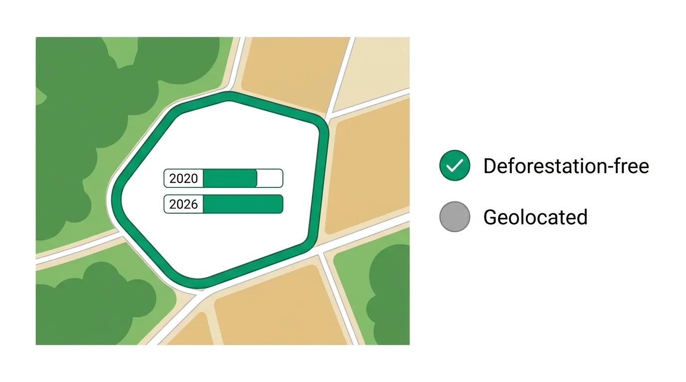
- Satellite imagery turns those coordinates into evidence. Once you know exactly where a plot is, you compare its forest cover at the 2020 baseline against now. If the trees are still there, that plot is deforestation-free, and you can show it.
- It applies to you even outside the EU. Any business placing covered goods on the EU market, or exporting them into it, carries the obligation, which is why “does EUDR apply to the UK” has a simple answer: if you sell into the EU, yes.
A shipment of cocoa arrives at Rotterdam. Before it clears, someone has to be able to show that the specific plots of land where those beans grew were not carved out of forest after the end of 2020. Not the region. Not the co-operative. The actual plots. With coordinates.
That, in one sentence, is what the EU Deforestation Regulation did to global supply chains. It shifted the burden of proof. For decades “sustainably sourced” was a claim you made. Under EUDR it’s a claim you have to evidence, plot by plot, and satellite imagery is the only practical way to do it at the scale of a real supply chain. Here’s how EUDR compliance actually works, and where the imagery fits.
What the EU Deforestation Regulation Actually Requires
Strip away the jargon and EUDR asks three things of every covered product before it can be sold in or exported from the EU.
It has to be deforestation-free. The commodity must come from land that was not subject to deforestation after 31 December 2020. That date is the line in the sand. Clear forest on 1 January 2021 to plant coffee, and that coffee is non-compliant, permanently. The regulation uses the FAO definition of forest, so the assessment is about genuine forest loss, not a farmer trimming a hedgerow.
It has to be legal. Production must comply with the relevant laws of the country of origin: land rights, environmental rules, labour law, anti-corruption. Deforestation-free but illegally produced still fails.
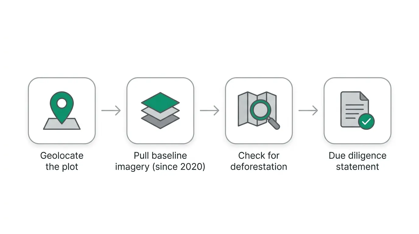
It has to be traceable to coordinates. This is the operational heart of it. Companies file a Due Diligence Statement (DDS) that includes the geolocation of every plot where the commodity was produced. No coordinates, no compliant statement, no sale.
When EUDR Applies: The 2026 and 2027 Deadlines
EUDR has been one of the most rescheduled pieces of EU legislation in recent memory, so the dates are worth getting right.
The regulation was originally meant to bite at the end of 2025. Weeks before that, in December 2025, the European Parliament and Council agreed another one-year postponement, alongside a set of simplifications. So the timeline that actually matters now is this:
| Company size | EUDR applies from |
|---|---|
| Large and medium operators and traders | 30 December 2026 |
| Micro and small enterprises | 30 June 2027 |
The delays have lulled some businesses into treating EUDR as a someday problem. That’s a mistake. The deforestation-free cutoff is still 31 December 2020, which means the evidence you’ll need in December 2026 is about land use that already happened. You can’t go back and re-photograph 2021. Either you have a clean imagery record for each plot or you’re reconstructing one, and reconstruction gets harder the longer you leave it.
Why Geolocation Is the Hard Part
Ask anyone mid-way through an EUDR programme what’s eating their time and it won’t be the satellite analysis. It’s getting coordinates for every plot in the first place.
The regulation wants polygons for any plot larger than 4 hectares and point coordinates for plots at or below that size. For a vertically integrated timber operation with a handful of large concessions, that’s manageable. For a chocolate company sourcing from tens of thousands of smallholder cocoa farms across West Africa, each often under a hectare, it’s an enormous data-collection exercise involving field teams, GPS apps and a lot of messy spreadsheets.
And the coordinates are only useful if they’re accurate. A plot boundary that’s offset by 50 metres will sit partly over the neighbour’s land, and when you run the deforestation check you’ll either flag clearing that wasn’t yours or miss clearing that was. Garbage coordinates produce garbage compliance evidence. The geolocation step and the imagery step are joined at the hip: precise boundaries make the satellite analysis trustworthy, and the satellite analysis is what makes the boundaries worth collecting.
How Satellite Imagery Proves a Plot Is Deforestation-Free
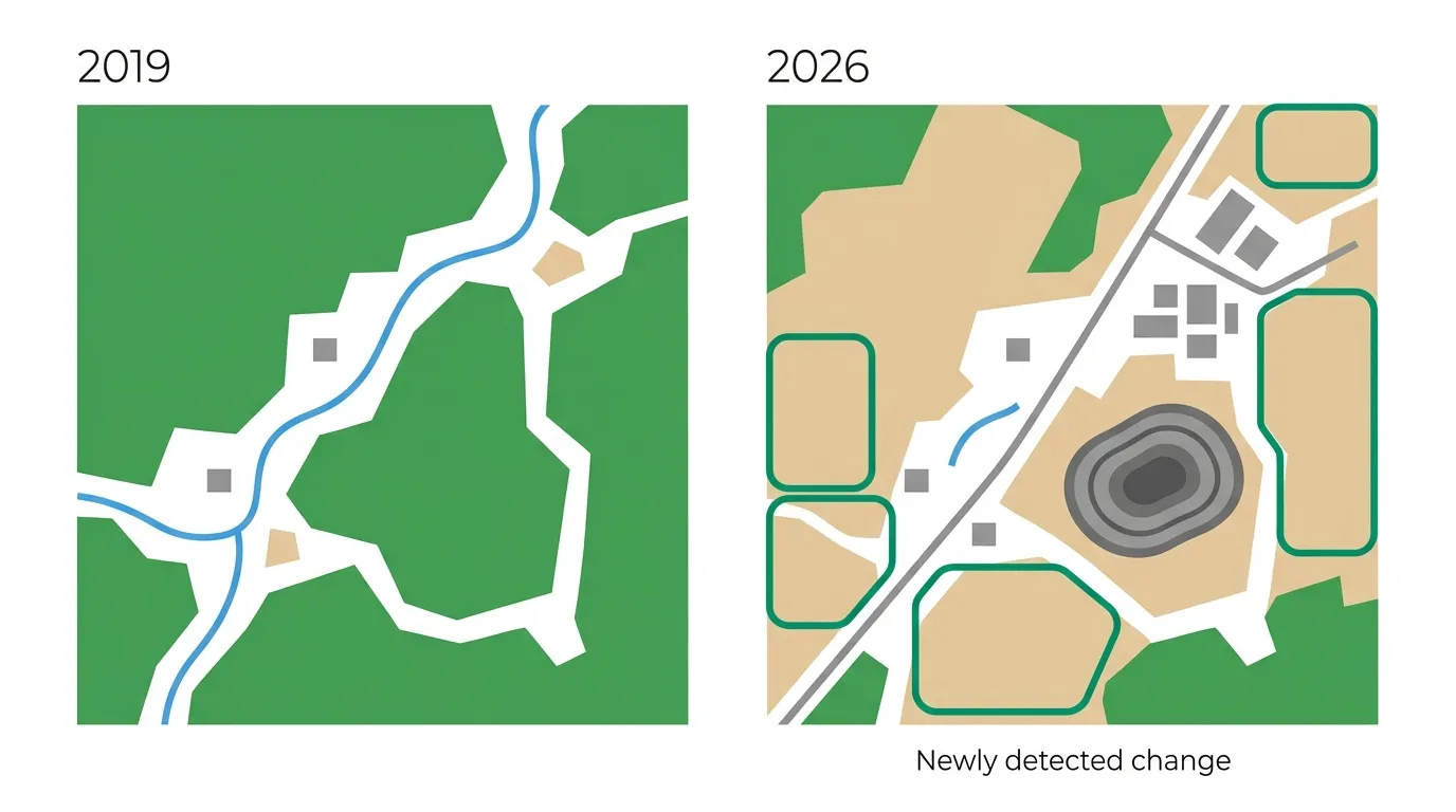
Once a plot has coordinates, satellite imagery answers the only question EUDR really cares about: was this land forest after the cutoff, and did that forest get cleared? You answer it by comparing the plot’s forest cover at the 2020 baseline against recent imagery. That comparison is satellite change detection, and it’s the engine under every EUDR monitoring platform on the market.
The baseline is where free archives earn their keep. Sentinel-2 has imaged the whole planet at 10-metre resolution every few days since 2015, which means a clean, consistent record of nearly every plot on Earth as it looked at the end of 2020 already exists, for free. Landsat stretches the record back to the 1970s if you need deeper context. We list where to pull both in our guide to free sources of satellite data. For a large plantation, 10-metre Sentinel-2 is often enough to settle the question on its own.
Smallholder plots are where it gets harder. At 10 metres, a sub-hectare cocoa farm is only a handful of pixels, and you can’t reliably tell a cleared corner from image noise. That’s when you task a high-resolution capture, sub-metre imagery from satellites like Beijing-3 or Jilin-1, to resolve change at the level of an individual field. The other recurring headache is cloud. The commodities EUDR targets grow mostly in the wet tropics, exactly where persistent cloud cover thins out your usable optical imagery, so a deep archive and frequent revisit matter as much as raw sharpness.
| Plot situation | Practical imagery approach |
|---|---|
| Large plantation or concession (>4 ha) | Free Sentinel-2 (10m) baseline vs recent, change detection on the polygon |
| Smallholder plot (under 4 ha) | High-resolution tasking (sub-metre) to resolve plot-level clearing |
| Persistent cloud (humid tropics) | Deep archive + frequent revisit to find clear-sky scenes near the dates you need |
| Deep historical context | Landsat archive to extend the record before 2015 |
None of this is exotic. It’s the same baseline-versus-now comparison used for monitoring mines or urban growth, pointed at a different question and tied to a regulatory date.
Getting EUDR-Ready Imagery Without the Headache
The imagery side of EUDR stalls in the same place every time: the free baseline is sitting there, but turning it into trustworthy, plot-level evidence means orthorectifying it so coordinates line up, atmospherically correcting it so two dates are actually comparable, and pairing free archive with sharp tasked imagery for the small plots. Skip any of that and your “deforestation” flags are as likely to be sun angle or misalignment as real forest loss.
That processing is what we do on every order, included in the base price rather than charged as an extra. Through one platform you can pull the Sentinel-2 and Landsat baseline for free, task sub-metre captures over the plots that need them across operators like Beijing-3, Jilin-1 and SuperView, and get all of it delivered already aligned and corrected, ready to drop against your plot boundaries. That’s the difference between imagery you can defend in a due diligence statement and imagery you have to caveat.
If you’re scoping an EUDR programme and working out the imagery layer, start with what’s available on our satellite imagery page, or tell us about your supply chain and we’ll help you work out which plots can ride on free Sentinel-2 and which need tasking. The deadline is fixed. The 2020 baseline isn’t getting any fresher.
Frequently Asked Questions
What is EUDR compliance?
EUDR compliance means demonstrating that commodities sold in or exported from the EU, cattle, cocoa, coffee, oil palm, rubber, soya and wood, plus derived products, come from land that was not deforested after 31 December 2020 and was produced legally. Proof is filed through a due diligence statement that includes the geolocation of every plot.
How do you comply with EUDR?
Collect the geolocation coordinates of every plot a commodity came from, assess each plot for deforestation after 31 December 2020 using satellite imagery, address any risk you find, and submit a due diligence statement. Polygons are required for plots over 4 hectares and point coordinates for smaller ones.
When is the EUDR deadline?
After a one-year delay agreed in December 2025, EUDR applies from 30 December 2026 for large and medium companies and 30 June 2027 for micro and small enterprises. The deforestation-free cutoff date stays fixed at 31 December 2020 regardless of the application date.
Does EUDR apply to the UK?
Yes, if you sell into the EU. EUDR applies to any operator or trader placing covered goods on the EU market or exporting them from it, wherever they are based. UK businesses supplying EU customers must comply. The UK is also developing its own separate forest risk commodity rules under the Environment Act.
What resolution of satellite imagery does EUDR need?
There’s no mandated resolution. Free 10-metre Sentinel-2 is usually sufficient for larger plots and plantations. Smallholder plots under a hectare often need sub-metre tasked imagery to resolve clearing reliably, because at 10 metres a small plot is only a few pixels.
Related Articles
Satellite Change Detection: How to Track Change Over Time
The method underneath EUDR proof: comparing imagery of the same plot across dates to map what changed.

Satellite Tasking Explained - A Practical Guide
How to order a fresh high-resolution capture of a specific plot when free archive imagery is not sharp enough.
