Google Earth Pro Desktop Is Being Discontinued: What Now?
Google Earth Pro desktop won't be downloadable after 25 June 2027. What the shutdown means, what still works, and what to use instead.
Summary
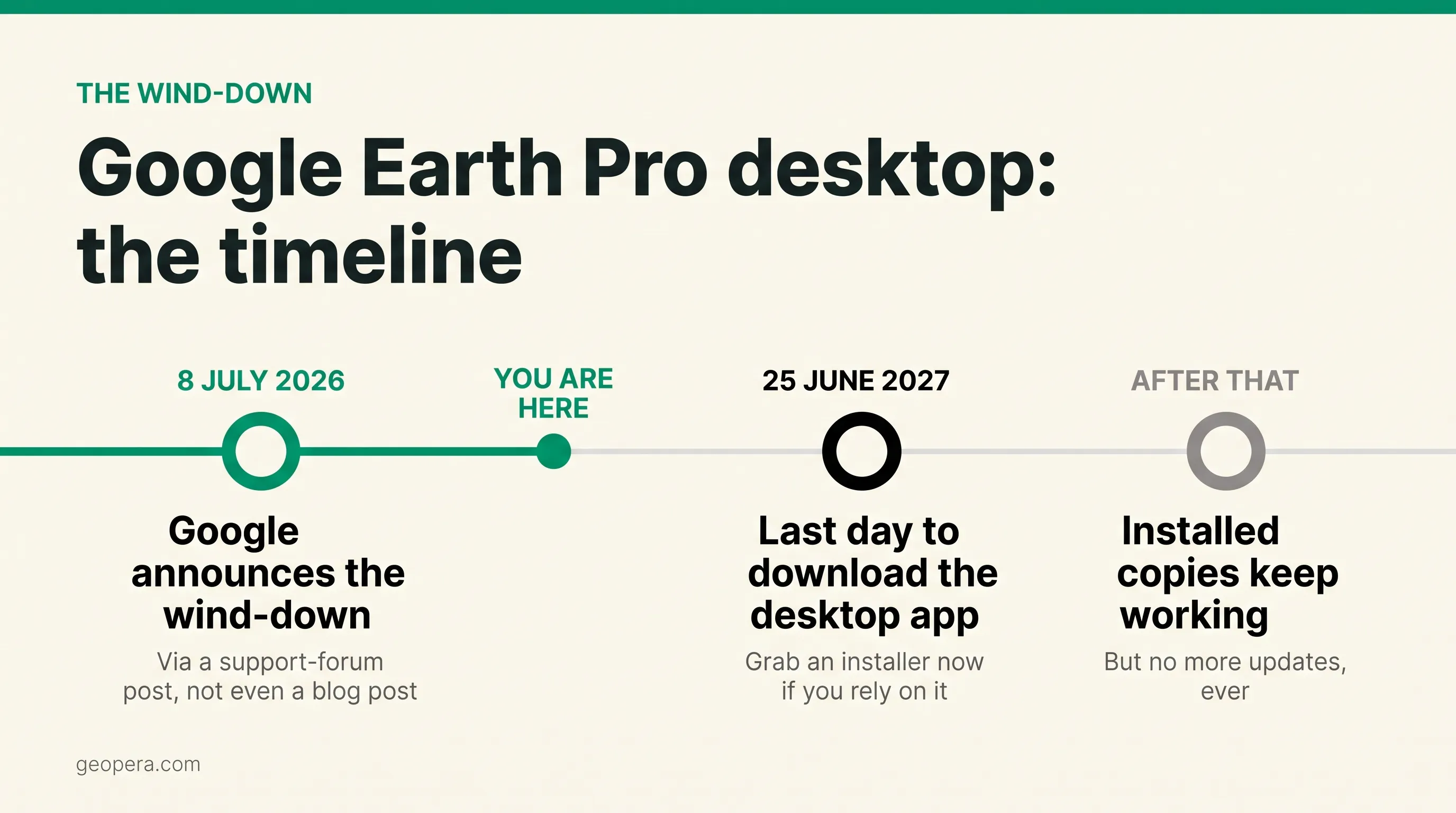
- Google announced on 8 July 2026 that Google Earth Pro desktop will no longer be available for download from 25 June 2027
- Already-installed copies keep working after the deadline, but they’ll receive no further updates
- Google’s suggested replacement is Google Earth on web and mobile, which users report caps KML imports at around 250,000 vertices and struggles to display attribute data
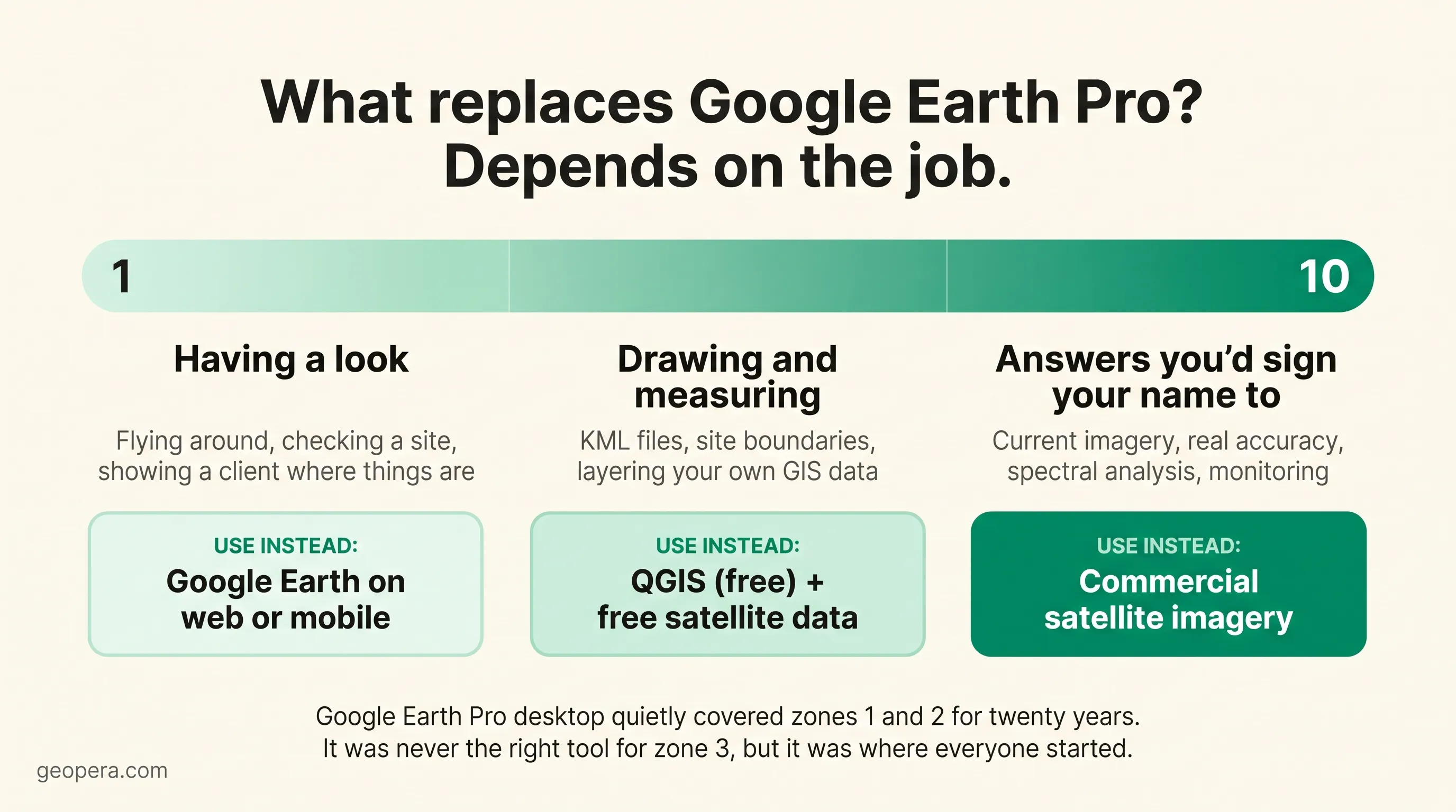
- Google Earth Pro was never one tool. It was three: a viewer, a lightweight GIS, and a screenshot machine. Each job has a different replacement
- For work that needs current, accurate, analysis-ready imagery, the replacement isn’t another free globe. It’s actual satellite data
Google Earth Pro has outlived Google Reader, Google+, Stadia, and close to 300 other products in the Google graveyard. Twenty-one years of dodging the axe. Then, on 8 July 2026, its number came up: Google Earth Pro desktop is being discontinued, with new downloads ending on 25 June 2027.
Google didn’t announce it with a press release, or even a blog post. The news went out as a support-forum notice.
If “open Google Earth” is step one of half your workflows, and in mining, surveying, agriculture and environmental consulting it usually is, this one’s for you. Here’s what’s actually happening, and what to move to.
What Google Actually Announced
The facts, stripped of the outrage:
- From 25 June 2027, the Google Earth Pro desktop application (Windows, macOS, Linux) will no longer be available for download
- Existing installations keep working. Google has confirmed the app will continue to function after the deadline for anyone who already has it
- No more updates, ever. No bug fixes, no imagery pipeline improvements, no security patches
- Google recommends migrating saved places and projects to Google Earth on web or mobile
So this is a slow fade rather than a kill switch. Your installed copy won’t stop working on 26 June 2027. It’ll just start ageing, and software that never gets patched again tends to age like milk rather than wine.
One wrinkle for Mac users: Google Earth Pro has no native Apple silicon build and runs through Rosetta 2 translation. Apple has already signalled that Rosetta will wind down after macOS 27. Mac users are on a shorter runway than the official date suggests.
Worth remembering how unlikely this product’s life was in the first place. Google bought Keyhole in October 2004, launched Google Earth in June 2005, and sold the Pro tier for US$399 a year until January 2015, when it became free. An enterprise-grade desktop globe, maintained for over a decade, at a price of zero dollars. The strange part is that it survived this long.
Why “Just Use the Web Version” Isn’t Landing Well
Google’s answer to every complaint is the web and mobile version of Google Earth. And to be fair, it has improved a lot. Historical imagery arrived on the web version in 2024, which closed one of the biggest gaps.
But professional users have been blunt about what’s missing. TechRadar’s coverage ran with the quote “the impact to thousands of companies across industries will be huge”, and the specifics behind that frustration are real:
- Users report the web version caps imported files at roughly 250,000 vertices, which rules out the large KML datasets that utilities, councils and exploration teams have built over years
- Attribute data attached to features often doesn’t display properly on web
- There’s no offline mode, which matters a great deal when your field site has the mobile coverage of the Moon
- Desktop staples like Movie Maker and direct GIS-format import have no web equivalent
None of this makes the web version bad. It’s a different product: a viewer. Google Earth Pro desktop grew into something closer to a Swiss Army knife, which is exactly why so many industries wove it into their workflows.
What People Actually Used Google Earth Pro For
Ask a geologist, a farm agronomist and a town planner what Google Earth Pro is for and you’ll get three different answers. That’s the point. It did several jobs at once, all free:
Reconnaissance. Fly to a site, have a look, get oriented. Nothing beats it for speed.
The KML lingua franca. For twenty years, KML files have been how field teams, consultants and clients swap spatial information without anyone needing GIS training. “I’ll send you a KML” is a complete sentence in half the industries in Australia.
The time slider. The historical imagery slider let anyone scrub back through decades of imagery for free. If you’ve used it to check what a paddock, pit or coastline looked like in 2005, you know why people are cranky. (We’ve written a full guide to finding historical satellite imagery of Australia that goes well beyond the slider.)
Measurements and screenshots. Rough areas, rough distances, and a thousand PowerPoint slides with that familiar globe watermark.
Each of those jobs has a replacement. But no single free product replaces all of them, and pretending otherwise is how people end up frustrated.
Similar Programs Like Google Earth Pro: What to Use Instead
The right replacement depends entirely on which of those jobs you’re replacing. Here’s the honest breakdown:
| Your job | Use instead | Cost | The catch |
|---|---|---|---|
| Browsing, presenting, quick looks | Google Earth (web/mobile) | Free | Vertex caps, patchy attribute display, no offline mode |
| KML work, site boundaries, layering GIS data | QGIS | Free | A learning curve. Genuine GIS software, not a toy |
| Free current imagery, vegetation checks | Copernicus Browser (Sentinel-2) | Free | 10 m resolution. Fields yes, fence lines no |
| Current high-resolution imagery, real analysis | Commercial satellite imagery via Pera Portal | Paid | Costs money. That’s genuinely the only catch |
A few notes on that table.
QGIS is the closest thing to a true Google Earth Pro desktop successor for the drawing-and-measuring crowd. It’s free, open source, runs natively on everything including Apple silicon, opens KML and KMZ directly, and will never be discontinued by a company chasing quarterly focus. The trade-off is that it’s real GIS software. Expect a weekend of YouTube tutorials before it feels natural.
Sentinel-2, the European Space Agency’s free workhorse, photographs every spot on Earth every five days at 10 m resolution. That’s dramatically fresher than Google Earth’s basemap, which is a mosaic that can be anywhere from months to years old depending on where you’re looking. We’ve pulled together the best free sources of satellite data if you want the full menu, Landsat included.
And commercial imagery is for when the free tier stops being enough, which brings us to the part most Google Earth Pro obituaries skip.
The Jobs Google Earth Pro Was Never Doing Anyway
A lot of organisations were using Google Earth Pro for work it was never built to support.
Google Earth’s imagery is a visual product, not a measurement product. The basemap is a mosaic stitched from many sources and dates, so you can’t control (or sometimes even know) when a given patch was captured. The imagery is compressed RGB, meaning no near-infrared band, no red edge, and therefore no NDVI or any of the vegetation analysis serious monitoring depends on. And positional accuracy varies from place to place, because the imagery is optimised to look right rather than to survey-grade standards. We’ve covered why orthorectification matters if you want the gory details.
If you were measuring a stockpile, dating a land clearing event, or putting a Google Earth screenshot in front of a regulator, the desktop app’s retirement isn’t your real problem. The imagery was.
For a fuller side-by-side, our comparison of Google Earth vs commercial satellite imagery breaks down where the free globe ends and professional data begins.
If the Deadline Is Your Nudge to Upgrade
We built Geopera for the moment a team realises “having a look” isn’t enough anymore.
Through Pera Portal, you can search archive imagery or task a new capture across satellites from multiple operators: WorldView at 30 cm, Beijing-3, Perascope, SuperView, plus Wyvern’s hyperspectral sensors. You pick the capture date instead of inheriting whatever mosaic Google served up. Every order is delivered orthorectified, pansharpened and atmospherically corrected at no extra cost, where most of the industry either charges 30-80% extra for processing or hands you raw files and wishes you luck.
Pricing is published openly on our pricing page, so you can work out whether a project stacks up before talking to anyone, and if commercial imagery is new territory, our guide on how to buy satellite imagery walks through the prices, licensing and ordering steps. If you’re not sure whether free Sentinel-2 covers your use case or you need 30 cm tasking, ask us. We’ll tell you honestly, including when the free option is the right answer.
Google Earth Pro earned its twenty-one years. Pour one out and grab an installer before June 2027. Then put the right tool behind each of the jobs it was doing for you.
Frequently Asked Questions
Is Google Earth Pro being discontinued?
The desktop application is. Google announced on 8 July 2026 that Google Earth Pro desktop won’t be available for download after 25 June 2027. Google Earth on web and mobile continues, and Google recommends migrating saved projects there.
Why is Google Earth Pro being discontinued?
Google has not given a detailed public reason. The 8 July 2026 announcement was a support-forum notice recommending migration to Google Earth on web and mobile, which is where development now happens. The desktop app never received a native Apple silicon build, which suggests investment in it stopped some time ago.
Is Google Earth going away too?
No. Only the Google Earth Pro desktop application is being discontinued. Google Earth on web and mobile continues, and it is Google’s recommended destination for saved places and projects. The web version added historical imagery in 2024, though users report a roughly 250,000 vertex cap on KML imports.
Can I still use Google Earth Pro after June 2027?
Yes, if it’s already installed. Google has confirmed existing installations keep working after the download cutoff. The app just won’t receive updates, bug fixes or security patches, so expect it to degrade slowly over time.
What are similar programs like Google Earth Pro?
Google Earth web or mobile covers browsing and presentations. QGIS, which is free and open source, handles KML files, measurement and GIS layers. For current, high-resolution, analysis-ready imagery, commercial platforms like Pera Portal replace what Google Earth never provided.
Is Google Earth Pro free?
Yes. Google Earth Pro has been free since January 2015, when Google dropped the US$399 annual fee. It stays free to download until 25 June 2027, so grab an installer now if your workflows depend on it.
What happens to my KML files and saved places?
KML is an open format, so nothing is lost. You can import saved places into Google Earth web (watch the roughly 250,000 vertex limit users report) or open KML and KMZ files directly in QGIS with no size restrictions.
