Satellite-Derived Bathymetry
Satellite-Derived Bathymetry
The seabed, mapped from orbit — validated against laser truth.
Within 38 centimetres of a survey-grade laser in clear water — accuracy at the front of the field, from Geopera's processing.
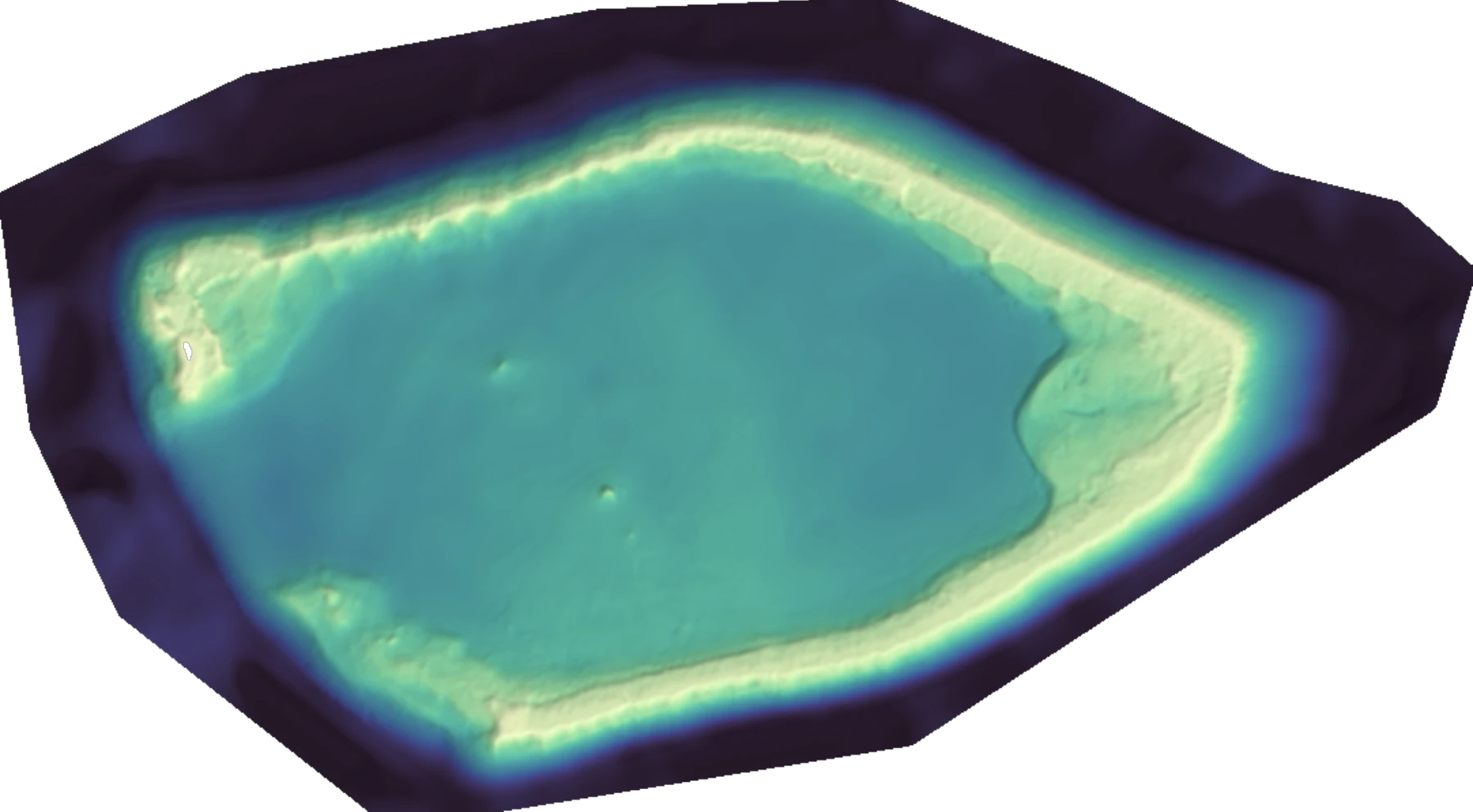
Sounding the seabed · Bahamas · 10 m grid · within 0.38 m of laser truth
Request a coastlineValidated against LiDAR
We put our depths next to airborne LiDAR
38 centimetres in clear water is the easy win, and we led with it. The honest test is the hard water. Jervis Bay in New South Wales is turbid, temperate and sediment-rich — the conditions that defeat most satellite bathymetry past a handful of metres. We mapped it from orbit, then laid our result beside a dense airborne LiDAR survey of the same seabed. Across the shallow margin — the part that carries the decisions — satellite and laser agree to within about a metre. Where the bottom drops out of sight, we leave it blank rather than guess.

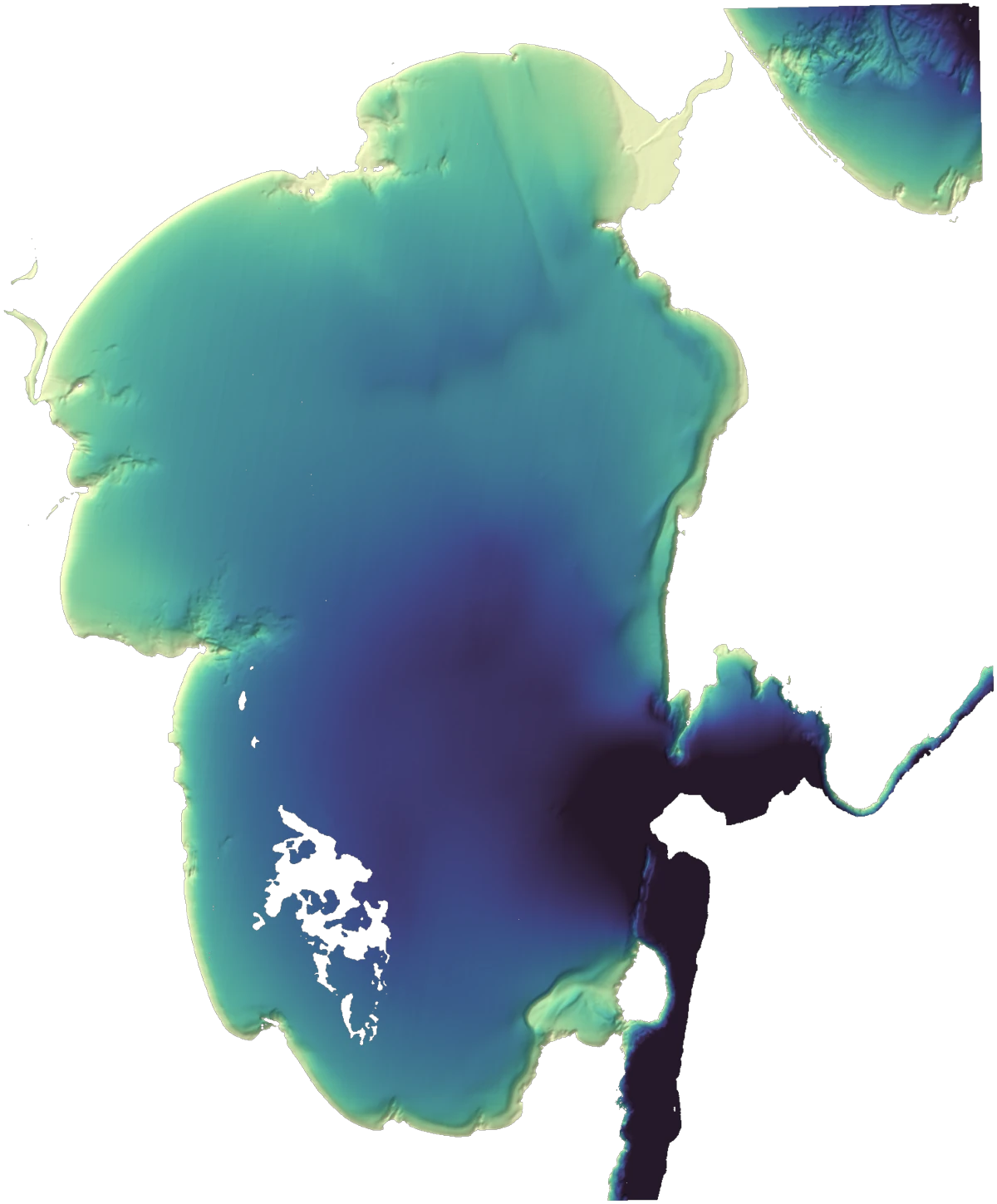
Jervis Bay, NSW — turbid temperate water, about a metre off the airborne LiDAR across the mapped shallows. Note the reference LiDAR is from 2018 and our imagery is 2026, so part of the difference is eight years of a genuinely moving seabed — not model error. Reference: NSW DCCEEW airborne LiDAR.
What makes ours different
Most satellite bathymetry gives you a single surface and a single accuracy number. We give you front-of-field accuracy, a surface that knows where it can be trusted, and the processing pedigree that produces both.
Accuracy at the front of the field
0.38 m against a survey-grade laser in clear water, about a metre against airborne LiDAR in turbid water. We publish the gap; most providers ship a single number and hope.
Our processing is the difference
Bathymetry is only as good as the imagery beneath it. Geopera's processing know-how — the same craft behind every order — recovers a clean seabed signal from each scene, and that's a large part of why our depths come out more accurate.
Every depth knows how sure it is
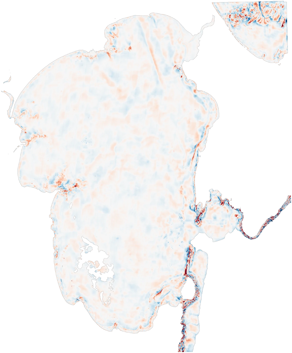
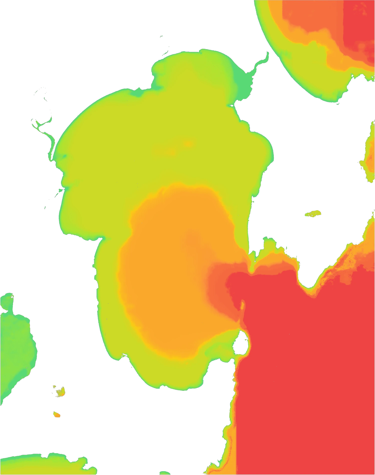
A depth without an error bar is a liability on the water. Each pixel carries its own calibrated error bound, a flag for where the seabed stops being visible, and a clear line between what we measured and what we inferred.
Clear water and turbid
We reach 38 cm in clear tropical water — and still hold about a metre in turbid, temperate water, where the easy methods run out of light at a few metres.
Global, delivered ready to use
Any sunlit coast, delivered as GeoTIFF with depth, uncertainty and visibility together — or on demand through our API. No field campaign to mobilise.
Honest about charting
Satellite bathymetry complements a hydrographic survey; it doesn't replace one. We say plainly where the result is chart-grade in clear shallow water and where it's reconnaissance in turbid.
Honest by pixel
Every depth knows how sure it is
A depth without an error bar is a liability on the water. So every Geopera pixel carries three things besides the depth itself. A calibrated error bound, telling you how far the real seabed could sit from the number. A bottom-visibility flag, marking where the seabed stops being optically visible — so we never report a depth we can't actually see. And a clear line between depth measured against laser truth and depth the model inferred between those points.
That's what turns a pretty surface into something you can plan against. You can set a safe working depth, decide which areas warrant a vessel before anyone relies on them, and know — pixel by pixel — where the map earns your trust and where it asks for caution.
Clear to turbid
One approach, the whole clarity spectrum
In the clear water of the Bahamas, we resolve the seabed to within 38 centimetres — the kind of fidelity people assume needs an aircraft and a laser. We get there by pairing the right imagery with processing built to pull the seabed signal cleanly out of it.
Point the same approach at the opposite extreme — the turbid, sediment-laden water of Jervis Bay, where simple methods collapse past a few metres — and it still holds about a metre across the shallows. Turbid, temperate coasts are the hardest case in the field, and the one most providers quietly cap out on. It's the case we built for.
Why our depths come out sharper
Anyone can point a satellite at the sea. The accuracy comes from what you do with the imagery next — and that's where Geopera's processing has years of hard-won edge.
The right imagery, every few days
We pull frequent-revisit multispectral imagery at a 10-metre grid over any sunlit coast, then pick the captures that actually see the seabed — the foundation everything else is built on.
Processing know-how most providers lack
The seabed signal is faint and easily swamped by haze, sun glint and suspended sediment. Geopera's imagery-processing pipeline — the same one behind every order — corrects all three to recover a clean, true signal. Cleaner inputs are most of what separates a depth you can trust from a guess.
Calibrated against laser truth
We calibrate every map against survey-grade laser depths, then ship a calibrated error bound and a bottom-visibility flag on each pixel — so you know exactly where to rely on it and where to verify.
Satellite, LiDAR, multibeam — when to use each
We don't pretend satellites replace a survey vessel. Satellite bathymetry gives you breadth, speed and scale; LiDAR and multibeam give you charting-grade truth. The strongest programmes use them together — and we validate ours against the others rather than competing with them.
| Satellite-derived | Airborne LiDAR | Multibeam sonar | |
|---|---|---|---|
| Coverage | Any sunlit coast, globally | Flight-line corridors | Vessel track lines |
| Cost per km² | Lowest — no field campaign | High — aircraft + crew | Highest — ship time |
| Revisit | Days (satellite cadence) | Per commissioned flight | Per commissioned survey |
| Max depth | ~15–20 m (water-clarity limited) | ~50–70 m | Unlimited |
| Best role | Reconnaissance, change, scale | Project-grade shallow survey | Charting-grade truth |
Frequently asked questions
It depends on the water and, frankly, on who is processing it. On a clear lagoon in the Bahamas, our depths land within 38 centimetres of survey-grade laser measurements of the same seabed — accuracy at the front of the field. In turbid, temperate water at Jervis Bay, where most satellite bathymetry gives up after a few metres, we hold about a metre against an airborne LiDAR survey. Every pixel also ships with its own calibrated error bound rather than a single headline figure you have to take on faith.
Map a coastline before you commission a survey
Tell us where you need depth. We'll turn around a validated satellite-derived bathymetry map — with honest uncertainty on every pixel — for any sunlit coast on Earth.