That Time Everyone Thought the Three Gorges Dam Was Collapsing Due to an Orthorectification Error
In 2019, satellite imagery showing distortions in China's Three Gorges Dam sparked global panic—but the dam was fine. The orthorectification wasn't.
Summary
In 2019, satellite images showing severe geometric distortion in China’s Three Gorges Dam went viral, sparking fears of structural failure and calls for mass evacuation. But the dam’s structural integrity was sound—the distortion existed only in the imagery processing. Inadequate orthorectification using insufficient elevation data for the 185-meter artificial structure created geometric artifacts that resembled structural deformation. This incident demonstrated that when monitoring critical infrastructure, the quality of image preprocessing directly affects whether you’re analyzing reality or processing artifacts. The lesson is clear: professional applications require professional-grade orthorectification with proper validation.
At Geopera, we deliver satellite imagery processed to professional standards—with comprehensive orthorectification, validated accuracy metrics, and complete documentation included at no extra cost—so you can trust that what you’re seeing represents reality, not processing artifacts.
When Bad Imagery Goes Viral
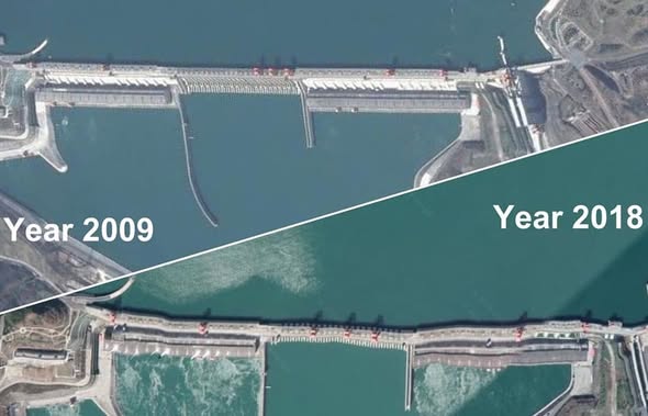
In July 2019, something unusual started appearing in social media feeds across China. Satellite images from Google Earth showed the Three Gorges Dam—one of the world’s largest engineering projects—with visible geometric distortion along its structure. Instead of the expected straight line spanning the Yangtze River, the images showed what appeared to be undulations and warping.
To understand why this was alarming: the Three Gorges Dam is over 2 kilometers wide, 185 meters tall, and holds back a reservoir extending 600 kilometers. Hundreds of millions of people live downstream. The dam’s scale is such that NASA detected measurable effects on Earth’s rotation when the reservoir was filled.
So when images suggested the structure might be deforming, the reaction was swift and severe.
Posts proliferated across Weibo, Twitter, and WeChat. Some claimed imminent structural failure. Screenshots circulated allegedly showing warnings from Huang Xiaokun, a senior engineer at the China Academy of Building Research, calling for immediate evacuations of the Yichang area. International media picked up the story. Suddenly “concerns about the Three Gorges Dam’s structural integrity” were making headlines worldwide.
Chinese authorities scrambled to respond. They released official statements, wheeled out engineers to explain the dam’s monitoring systems, and published alternative high-resolution imagery from the Gaofen-6 satellite showing the structure perfectly straight.
The dam was fine. It had always been fine.
But the imagery processing? That was another story.
The Technical Reality: What Orthorectification Does (and What Happens When It Fails)
Here’s what most people don’t realize about satellite imagery: what satellites capture isn’t immediately usable for accurate measurement or analysis. Raw satellite data contains geometric distortions that need to be corrected before the imagery can be trusted for professional applications.
This correction process is called orthorectification, and it’s fundamental to turning satellite acquisitions into analysis-ready data.
How Orthorectification Works
When a satellite captures imagery, several factors introduce geometric distortions:
- Sensor geometry: The satellite’s position, attitude, and viewing angle at acquisition
- Terrain relief: Elevation variations cause displacement, especially in oblique imagery
- Earth curvature: The spherical nature of Earth affects pixel positioning
- Platform motion: The satellite’s movement during image capture
Think of it this way: if you photograph a tall building from an angle, the building appears to lean. The top of the building is displaced from its base in the image, even though the building itself is vertical. This is relief displacement, and it happens with every feature that has elevation when photographed from an oblique angle.
Now scale that up to entire landscapes with mountains, valleys, and yes—large artificial structures like dams.
Orthorectification corrects these distortions by using:
- Rational Polynomial Coefficients (RPCs): Metadata describing the mathematical relationship between image coordinates and ground coordinates
- Digital Elevation Models (DEMs): Detailed terrain height information
- Ground control points (GCPs): Known positions used for validation in high-accuracy applications
When done properly, you get an orthophoto where every pixel represents its true ground position. Features appear where they actually are, measurements are reliable, and you can overlay the imagery with other geospatial data without misalignment.
When done improperly—or when the input data is inadequate—you get the Three Gorges Dam incident.
The Perfect Storm: Why the Dam Processing Failed
The Three Gorges Dam presented a particularly challenging case for automated orthorectification:
The elevation problem: The dam is a 185-meter tall artificial structure creating a massive elevation change. Standard DEMs, which typically derive from natural terrain data, often don’t include accurate elevation information for recently constructed large-scale infrastructure. Without accurate elevation data for the dam itself, the orthorectification algorithms were essentially trying to correct for terrain that their model said was much flatter than reality.
The stitching problem: Google Earth creates its global imagery by mosaicking together satellite and aerial photographs acquired at different times, from different angles, under different atmospheric conditions. Each individual image requires orthorectification before being integrated into the mosaic. When the elevation model is inadequate, each image gets corrected slightly differently, creating visible distortions when they’re stitched together.
The algorithm problem: Consumer mapping platforms optimize for global coverage and processing speed rather than precision for every specific feature. Their algorithms work well for most use cases—natural terrain, low-relief areas, standard structures. But edge cases like 185-meter dams spanning major rivers can break the assumptions these algorithms rely on.
The result? Geometric artifacts that made a perfectly stable structure look deformed.
Why Smart People Believed Bad Data
Here’s the uncomfortable part: the imagery looked convincing. People weren’t being irrational when they panicked.
The distortions were visible, consistent across multiple viewpoints in Google Earth, and appeared in what most people consider an authoritative source. When you zoom in on Google Earth and see imagery that looks photographic, it’s natural to trust what you’re seeing.
This is the hidden risk of democratized satellite imagery access. Platforms like Google Earth have made satellite imagery available to billions of people—an incredible achievement. But most users don’t understand the processing that happens between satellite acquisition and the image they see on screen. They don’t know to look for processing artifacts. They don’t know that certain features (like very tall structures) are more prone to orthorectification errors.
And when the stakes are high enough—when you’re looking at infrastructure protecting hundreds of millions of people—misinterpreting geometric artifacts as structural deformation becomes genuinely frightening.
The Chinese government faced an interesting challenge: they needed to prove that the imagery was wrong, not the dam. That’s a hard sell when people can see the “evidence” with their own eyes.
The Broader Implications for Remote Sensing Applications
The Three Gorges Dam incident isn’t just an interesting case study—it’s a warning about the real-world consequences of inadequate image processing across professional applications.
When Orthorectification Quality Matters
Infrastructure monitoring: Accurate geometric positioning is essential for detecting actual deformation, measuring clearances, and planning maintenance. Geometric artifacts that mimic structural movement can trigger false alarms or, worse, mask real problems.
Mining operations: Pit wall stability analysis depends on accurate 3D positioning over time. Orthorectification errors of several meters can make stable walls appear to be moving or obscure dangerous actual movement.
Precision agriculture: Field boundaries, equipment guidance, and yield mapping all require sub-meter accuracy. Poor orthorectification means GPS-guided equipment doesn’t match the imagery, leading to inefficient operations.
Environmental monitoring: Tracking coastal erosion, glacier retreat, or deforestation requires comparing imagery over time. If images from different dates have different geometric errors, you’re measuring processing differences rather than actual change.
Disaster response: After earthquakes or floods, response teams use satellite imagery to assess damage and prioritize resources. Geometric distortions could show damage where none exists or miss critical areas.
Legal and regulatory applications: Property boundaries, environmental compliance, and planning approvals often depend on satellite imagery. Geometric inaccuracies can have legal consequences.
The pattern is clear: when decisions have consequences—safety, financial, legal, environmental—the quality of orthorectification becomes non-negotiable.
Professional Standards vs. Consumer Platforms
Consumer mapping platforms like Google Earth serve a different purpose than professional remote sensing applications. They prioritize:
- Global coverage over local precision
- Processing speed over validation
- Visual consistency over geometric accuracy
- Accessibility over technical documentation
This approach works well for their use case: providing general reference imagery to billions of users. But it creates problems when people use consumer imagery for professional applications without understanding its limitations.
Professional orthorectification, by contrast, requires:
High-resolution elevation data: Standard DEMs might be 30-90 meter posting. Professional applications often require 1-meter or better resolution, particularly around complex terrain or artificial structures. For the Three Gorges Dam, proper orthorectification would need elevation data that accurately represents the dam’s 185-meter height and geometric complexity.
Appropriate algorithms: Different terrain types, structure heights, and sensor geometries require different correction approaches. Professional workflows adapt the orthorectification method to the specific characteristics of each scene.
Rigorous validation: Processed imagery should be verified against ground control points to quantify accuracy. Professional applications typically target sub-pixel geometric accuracy and document achieved RMSE (Root Mean Square Error).
Proper documentation: Professional imagery delivery includes metadata specifying DEM source and resolution, processing methods, geometric accuracy assessment, and coordinate system information.
Computational resources: Processing high-resolution imagery with detailed elevation models and sophisticated algorithms requires significant infrastructure that consumer platforms don’t apply to every pixel of global coverage.
What Professional Orthorectification Looks Like
Let’s be specific about what separates adequate processing from professional-grade orthorectification.
The Input Requirements
Imagery quality: Starting with high-quality raw imagery with complete metadata, including RPCs, sensor calibration information, and acquisition parameters.
Elevation models: Using DEMs with resolution appropriate to the application. For infrastructure monitoring, this often means 1-meter or better resolution. For the Three Gorges Dam, this would require elevation data that accurately captures the dam’s geometry, possibly derived from stereo imagery or lidar specifically acquired for the structure.
Ground control: When absolute positional accuracy is critical, incorporating GCPs with known coordinates to refine the geometric model. Professional applications might use 10-20 well-distributed GCPs depending on area size and accuracy requirements.
The Processing Standards
Professional orthorectification workflows include:
- Sensor-specific correction algorithms that account for each satellite’s unique optical characteristics
- Adaptive resampling methods that preserve radiometric fidelity while correcting geometry
- Automated quality assessment checking for residual distortions
- Validation against independent reference data
- Documentation of achieved geometric accuracy
The Validation Process
This is where professional processing diverges most from consumer platforms. Professional imagery undergoes systematic validation:
Checkpoints: Independent ground control points not used in the processing are used to assess accuracy
Accuracy metrics: RMSE, CE90 (Circular Error 90%), or other standard metrics quantify geometric precision
Visual inspection: Experienced analysts review the imagery for artifacts, edge effects, and alignment issues
Cross-validation: When possible, comparing with other data sources to verify consistency
The result is imagery where you know the accuracy, understand the limitations, and can trust measurements derived from it.
The Geopera Approach: Making Professional Processing Standard
At Geopera, our philosophy is straightforward: satellite imagery should be delivered ready for professional use, with the processing quality that critical applications demand.
Every image from our platform undergoes comprehensive orthorectification using:
- High-resolution elevation models appropriate for each scene’s characteristics
- Advanced algorithms that adapt to terrain complexity and feature types
- Rigorous quality control ensuring sub-pixel geometric accuracy
- Complete validation with documented accuracy metrics
This isn’t positioned as a premium service or optional add-on—it’s our standard. Because we believe inadequate orthorectification isn’t just a technical shortcoming; it’s a fundamental failure to deliver usable data.
For applications monitoring infrastructure, analyzing environmental change, planning operations, or supporting critical decisions, you need to know that what you’re seeing represents reality, not processing artifacts.
We handle the complexity—elevation data acquisition, algorithm selection, computational processing, quality validation—so you can focus on analysis and insights rather than questioning whether your imagery is geometrically reliable.
Learn more about why we process every image to professional standards.
What to Look for in Satellite Imagery Providers
If you’re sourcing satellite imagery for professional applications, here are the questions you should ask:
What DEM resolution is used for orthorectification? If the answer is vague or the provider doesn’t specify, that’s a red flag. Professional processing requires elevation data appropriate to the application.
What geometric accuracy is achieved? Look for specific metrics—RMSE in meters or CE90 values. “High accuracy” or “professional quality” without numbers means nothing.
How is accuracy validated? There should be independent checkpoints and documented validation procedures.
Is processing documentation included? Professional delivery should include metadata specifying processing methods, elevation data sources, coordinate systems, and accuracy assessment.
Can you provide custom processing? Different applications have different requirements. A provider should be able to discuss trade-offs between processing approaches and adapt to your specific needs.
If a provider can’t answer these questions, or if orthorectification is treated as an optional upgrade, you’re likely getting consumer-grade processing inadequate for professional applications.
The Takeaway
The Three Gorges Dam incident happened because imagery processing designed for general consumer use was interpreted as if it had professional-grade geometric accuracy. The dam wasn’t failing—the orthorectification was inadequate for that specific application.
This matters beyond China and beyond large dams. Every day, decisions get made based on satellite imagery. Some of those decisions affect safety, investments, environmental protection, or legal compliance. When the imagery processing is inadequate, those decisions get made on faulty information.
The solution isn’t to distrust all satellite imagery. The solution is to understand that not all imagery is created equal, and to demand professional-grade processing for professional applications.
Consumer platforms are excellent for what they’re designed to do. But when accuracy matters—when you’re measuring, monitoring, or analyzing features where precision affects outcomes—you need imagery processed to professional standards, with validation to prove it.
Nobody needs their own Three Gorges Dam moment. Whether you’re monitoring infrastructure, managing resources, or conducting environmental analysis, you deserve imagery that shows reality, not artifacts.
Ready to work with properly processed satellite imagery? Explore the Pera Portal to see what professional-grade orthorectification delivers. Every image comes with complete processing and documented accuracy—because that’s what professional applications require.
Or contact our team to discuss your specific requirements. We’re here to ensure your satellite imagery supports confident decision-making, not confusion about whether what you’re seeing is real.
Frequently Asked Questions
Q: How common are orthorectification errors in consumer satellite imagery platforms?
Geometric artifacts are relatively common in consumer platforms, particularly in areas with extreme relief, tall artificial structures, or at the edges of image tiles where different acquisitions are mosaicked together. Most users don’t notice because they’re using the imagery for general reference rather than precision measurements. The Three Gorges Dam case was unusual because the stakes were high enough to generate panic when people noticed the distortions.
Q: Can orthorectification errors be corrected after imagery is delivered?
In some cases, yes—if you have access to the original raw imagery, proper elevation data, and the technical expertise. However, this requires essentially reprocessing the imagery from scratch, which is why it’s far more efficient to ensure proper orthorectification during initial processing. Trying to “fix” poorly orthorectified imagery is technically challenging and often produces suboptimal results.
Q: What accuracy should I expect from professionally orthorectified imagery?
This depends on several factors including sensor resolution, DEM quality, and whether ground control points are used. For high-resolution satellite imagery (0.3-1m resolution) with proper orthorectification, you should expect horizontal accuracy of 2-3 meters RMSE without GCPs, or sub-meter accuracy when GCPs are incorporated. Your provider should document the achieved accuracy for your specific imagery.
Q: Is Google Earth imagery suitable for any professional applications?
Google Earth imagery can be appropriate for reconnaissance, general planning, visual reference, and applications where approximate positioning is sufficient. However, for applications requiring accurate measurements, change detection, or integration with other geospatial datasets, professionally orthorectified imagery with documented accuracy is necessary. Always match the imagery quality to your accuracy requirements.
Q: How much does professional orthorectification typically add to imagery costs?
With traditional providers, orthorectification can add 30-80% to base imagery costs, and high-accuracy processing with GCPs can cost even more. At Geopera, we include professional-grade orthorectification as standard with every order at no additional cost, because we believe analysis-ready imagery is the only type worth delivering.
Related Articles

Orthorectification: Turning Raw Satellite Data Into Map-Ready Imagery
Learn how orthorectification transforms raw satellite imagery into geometrically accurate, analysis-ready data through terrain correction.
Understanding DEMs, DSMs, and DTMs: A Complete Guide to Digital Elevation Data
Comprehensive guide to digital elevation models and their critical role in accurate satellite imagery processing.
Why We Process Every Image
Discover why professional-grade processing is essential for satellite imagery and how it affects your analysis outcomes.
