Using WorldView-3 SWIR to Enable Individual Alteration Mineral Mapping
How 16-Band SWIR Imagery Enables Precise Hydrothermal Alteration Mapping for Mineral Exploration
Get the Complete WorldView-3 Alteration Zone Analysis
Access the complete technical analysis with detailed band ratio methodology, mineral maps, and structural interpretation.
The Challenge: Remote Mineral Exploration
Traditional mineral exploration requires expensive field surveys to identify promising areas. Hydrothermal alteration minerals - the key indicators of potential mineralisation - create unique spectral signatures in the shortwave infrared (SWIR) range that can be detected remotely, vastly improving how we approach early-stage exploration.
WorldView-3: Game-Changing SWIR Technology
WorldView-3’s advanced 8-band SWIR sensor (1195-2365 nm at 3.7m resolution) captures diagnostic absorption features of critical alteration minerals:
- Phyllosilicates: Kaolinite, illite, smectite, muscovite, chlorite
- Sulfates: Alunite, jarosite, gypsum
- Iron minerals: Hematite, goethite, pyrite
- Carbonates: Calcite, dolomite
Breakthrough Results
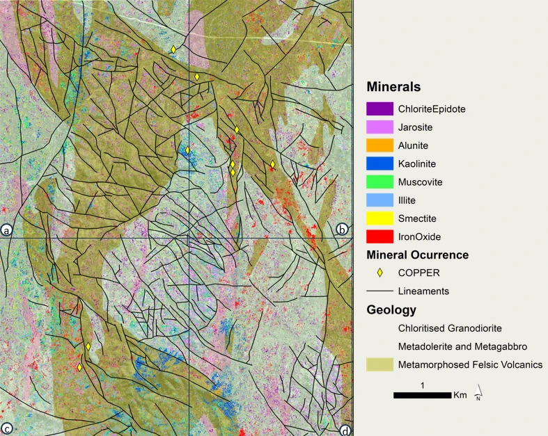
Working with a geologically complex area featuring chloritized granodiorite, metamorphosed volcanics, and known mineralisation zones, Arc GeoTech achieved:
Precise Mineral Mapping
- Successfully identified and mapped distinct alteration mineral assemblages
- Detected clay-rich zones with kaolinite, illite, smectite, and muscovite
- Mapped iron oxide concentrations and sulfate mineral occurrences
- Distinguished between different alteration types and intensities
Structural Discovery
- Revealed high-density fault networks with primary NW-SE and NNW-SSE trends
- Demonstrated strong correlation between alteration zones and structural lineaments
- Identified structural controls on mineralisation pathways
Advanced Analysis Methods
Arc GeoTech’s multi-technique approach combined:
- Band ratio analysis targeting specific mineral signatures
- Spectral Angle Mapper (SAM) classification with reference spectra
- Multi-band composites optimised for alteration discrimination
- High-resolution lineament analysis using 30cm panchromatic data
Get the Complete Technical Analysis
The comprehensive report delivers:
- Step-by-step processing workflows with detailed parameters
- Complete mineral distribution maps with classification confidence
- Structural analysis including rose diagrams and lineament density maps
- Band ratio formulations for different mineral targets
- Visual spectral comparisons across all composite combinations
- Geological targeting recommendations for follow-up exploration
Download the full technical case study →
Case study prepared by Arc GeoTech utilising Geopera data