Scaling Carbon Stock Assessment by Leveraging High-Resolution Satellite Imagery
How Commercial Satellite Data Delivers 28% Better Vegetation Detection at a Fraction of the Cost
Get the Complete Carbon Assessment Case Study
Want the full case study with detailed methodology, visual comparisons, and implementation guidelines? Complete the form below to get instant access to our comprehensive PDF version.
The Carbon Measurement Challenge
As carbon stock assessment scales from local projects to regional territories, organizations face mounting pressure to:
- Measure accurately across increasingly vast areas
- Reduce costs while maintaining data quality
- Deliver timely assessments to meet regulatory requirements
- Detect smaller vegetation features critical for precise carbon calculations
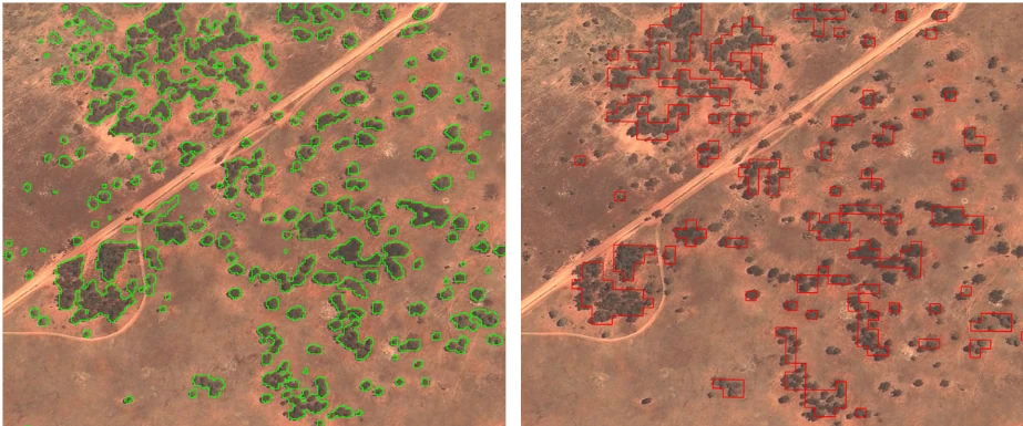
Key Findings from Our Comparison Study
Our analysis compared high-resolution commercial satellite imagery (Jilin-1) with freely available Sentinel-2 data:
- 28% increase in vegetation detection using Jilin-1’s 50cm resolution
- Individual tree crown identification versus only detecting larger vegetation clusters
- Significantly improved boundary accuracy for more precise carbon calculations
- Daily revisit capability compared to Sentinel-2’s 5-day revisit frequency
Cost-Effective Solution
At just $0.12 AUD per hectare, Jilin-1 imagery offers:
- ✅ 5-10x cost savings compared to traditional aerial or drone surveys
- ✅ Superior resolution to free satellite options (50cm vs 10m)
- ✅ Scalability across vast assessment territories
- ✅ No practical deployment limitations unlike drone surveys
Download the Complete Case Study
The full report includes:
- Detailed methodology of our comparative analysis
- Visual examples showing detection differences
- Cost-benefit analysis across multiple project scales
- Implementation guidelines for integrating high-resolution data into your carbon assessment workflow
- Complete comparative specifications of remote sensing options
Access the full case study now →
Prepared by Geopera | Helping organizations make better environmental decisions with precision satellite data