Hyperspectral Arrives: Geopera Partners with Wyvern
Geopera is excited to announce our partnership with Wyvern, bringing high-resolution hyperspectral satellite imagery to Australian organisations through our platform
Geopera Partners with Wyvern to Bring Hyperspectral Imagery to Australian Users
We’re pleased to announce that Geopera has partnered with Wyvern, adding high-resolution hyperspectral satellite imagery to our data offerings for the Australian market. This collaboration enables our customers to access Wyvern’s Dragonette constellation data directly through the Pera Portal, providing new analytical capabilities for various applications specific to Australian environments and industries.
For those unfamiliar with hyperspectral imagery and its applications, let’s explore what this technology offers:
Understanding Hyperspectral Imagery
When we refer to “spectral,” we’re discussing portions of the electromagnetic spectrum—the range of energy wavelengths that includes everything from gamma rays to radio waves. While human vision is limited to the visible light spectrum (approximately 380-750 nanometers), some satellite sensors can detect a much broader spectral range.
Traditional multispectral satellites capture 4-10 colours, or spectral bands. These spectral bands sample some portion of th overall spectral range. Hyperspectral imagery significantly expands this capability by capturing dozens of narrow, contiguous spectral bands across the spectral range, greatly increasing the amount of spectral information taken of the scene.
The value of hyperspectral data lies in its ability to detect distinctive spectral signatures. Each material on Earth has a unique way of reflecting or absorbing different wavelengths based on its molecular composition. With the improved spectral sampling of hyperspectral imagery giving a better represntation of these distinct spectral signatures, imagery can be used to distinguish between similar materials, identify specific vegetation types, detect particular minerals, or monitor environmental conditions with greater precision than conventional multispectral imagery allows.
Wyvern’s Dragonette Constellation
Founded in 2018 in Edmonton, Canada, Wyvern specialises in commercial hyperspectral imaging. Their Dragonette constellation currently includes four satellites (Dragonette-001 to -004) delivering 5.3 m ground sampling distance (GSD) imagery over 23-31 spectral bands in the visible near infrared (VNIR) range.
Wyvern plans to expand the constellation with Dragonette-005, and 006 beginning later this year, which will increase coverage and revisit frequency.
The Dragonette constellation provides 5.3m resolution hyperspectral imagery, offering higher resolution than previously available commercial hyperspectral satellite options. This combination of spatial detail and spectral range makes it suitable for a variety of applications across different industries.
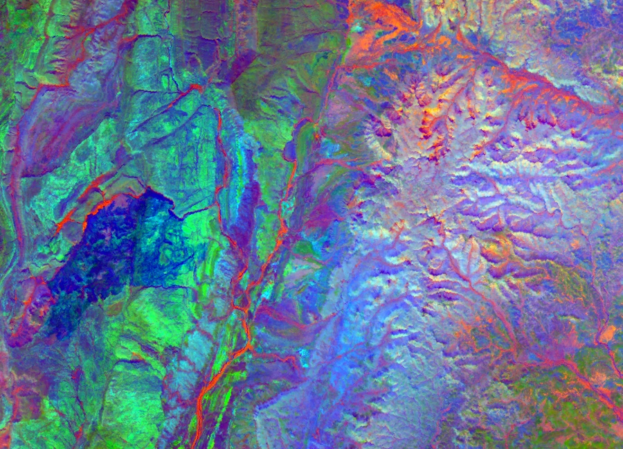 Dragonette-001 image of Purnululu National Park, Western Australia taken on February 2nd, 2025 01:33:30 UTC (PCA). ©2025 Wyvern Incorporated. All Rights Reserved.
Applications: Hyperspectral Solutions for Local Challenges
Australia faces unique environmental and agricultural challenges that hyperspectral imagery is particularly well-suited to address:
Mining Rehabilitation
With Australia’s extensive mining operations across Western Australia, Queensland, and New South Wales, environmental rehabilitation monitoring is a critical concern. Hyperspectral data can help:
- Monitor mine site rehabilitation progress with precision
- Detect acid mine drainage issues specific to Australian geological conditions
- Assess native vegetation regrowth on remediated sites
- Ensure compliance with Australia’s strict environmental regulations
Agriculture and Drought Monitoring
Australia’s agricultural sector regularly faces drought conditions and requires precise water management. Hyperspectral imagery provides:
- Early stress detection in key Australian crops like wheat, cotton, and sugar cane
- Improved water use efficiency through detailed crop health monitoring
- Better discrimination between similar crop varieties in Australian farming systems
- Support for precision agriculture practices in Australia’s variable climate conditions
Bushfire Management
Following devastating bushfire seasons, Australian land managers need better tools for prevention and recovery assessment. Wyvern’s Dragonette constellation offers:
- Enhanced fuel load mapping in eucalypt forests and other Australian vegetation types
- Improved detection of vegetation dryness before it becomes visibly apparent
- Post-fire recovery monitoring of native Australian ecosystems
- Data to support bushfire planning specifically tailored to Australian conditions
The addition of Wyvern’s hyperspectral capabilities to Geopera’s platform provides Australian organizations with locally-relevant tools to address these national priorities.
Geopera + Wyvern: Expanding Access to Hyperspectral Data for Australian Users
Through this partnership, Geopera customers across Australia can now access Wyvern’s hyperspectral data through our Pera Portal platform with several advantages:
- Integration with Geopera’s processing pipeline for efficient delivery
- Compatibility with existing geospatial workflows
- Streamlined data access through the Pera Portal
- Local technical support from our Australian-based team
This partnership provides Australian organisations in agriculture, environmental monitoring, forestry, mining, and related fields with practical tools to enhance their geospatial analysis capabilities while addressing regional challenges.
Access Wyvern Data Through Geopera
For Australian organisations ready to explore hyperspectral imaging capabilities:
- Log in to Pera Portal to view available Wyvern data coverage across Australia
- Contact our Australian team for information about data specifications and regional availability
Wyvern’s hyperspectral data for Australian territories is now available on the Pera Portal.
Learn More about Wyvern
Learn more about Wyvern at https://wyvern.space/
